1940s Maps of Piney Bend, Alabama
Explore 2 historic maps of Piney Bend from the 1940s. These maps offer a rare glimpse into what life looked like during the 1940s — showing old roads, neighborhoods, homes, and landmarks that have changed or disappeared over time.
Whether you're researching your family's past, planning a metal detecting trip, or studying how Piney Bend's landscape evolved across the 1940s, these high-resolution maps are a powerful tool for exploring the history of this region.
- Focus on a specific era: All maps on this page are from the 1940s, giving you a focused view of this time period.
- See what’s changed: Compare century-old streets, trails, and buildings to today's modern landscape using overlays and satellite layers.
- Research with precision: Use these maps for genealogy, historical research, land use analysis, or educational projects.
- View, download, or print: Maps are fully viewable online in high resolution, and can be downloaded or printed for your own records.
Start exploring Piney Bend's history through authentic maps from the 1940s. This is your window into the past.
Piney Bend, AL maps
(2)- 1946 Map of Guinn Cross Roads, 1970 Print
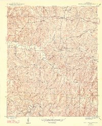
 1946 Guinn Cross Roads1970 Print · USGSFranklin County's rural interior is captured here in the mid-1940s, just as the TVA was planning the Little Bear Creek Dam (proposed). Genealogists can trace old family sites near Bradley Chapel, Old Nauvoo, and the Macedonia Cem.
 - 1947 Map of Guinn Cross Roads
 1947 Guinn Cross Roads1947 Print · USGSFranklin County's interior during the late 1940s reveals a landscape of isolated farmsteads and rural congregations. Genealogists can trace family names and local history through Guinn Cross Roads, Old Nauvoo, and the numerous grounds of Friendship Cem.2 unique versions available
End of results
Showing maps 1-2 of 2
Top cities near Piney Bend
- Red Bay historical maps
- Belmont historical maps
- Hackleburg historical maps
- Vina historical maps
- Hodges historical maps
- Golden historical maps
Frequently asked questions
- What are the different types of historical maps available for Piney Bend?
- What is the oldest map of Piney Bend?
- Where can I purchase historical maps of Piney Bend for my home or office?
- Where can I download high-res historical maps of Piney Bend?
- Are there historical topographic maps available for Piney Bend?
- Is there historical aerial imagery available for Piney Bend?
- Where are historical maps of Piney Bend sourced from?