1970s Maps of Warrior, Alabama
Explore 1 historic maps of Warrior from the 1970s. These maps offer a rare glimpse into what life looked like during the 1970s — showing old roads, neighborhoods, homes, and landmarks that have changed or disappeared over time.
Whether you're researching your family's past, planning a metal detecting trip, or studying how Warrior's landscape evolved across the 1970s, these high-resolution maps are a powerful tool for exploring the history of this region.
- Focus on a specific era: All maps on this page are from the 1970s, giving you a focused view of this time period.
- See what’s changed: Compare century-old streets, trails, and buildings to today's modern landscape using overlays and satellite layers.
- Research with precision: Use these maps for genealogy, historical research, land use analysis, or educational projects.
- View, download, or print: Maps are fully viewable online in high resolution, and can be downloaded or printed for your own records.
Start exploring Warrior's history through authentic maps from the 1970s. This is your window into the past.
Warrior, AL maps
(1)- 1975 Map of Warrior, 1977 Print
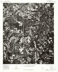 1975 Warrior1977 Print · USGSJefferson County in the mid-seventies is seen here through high-resolution aerial imagery, revealing the literal landscape of the Alabama coal belt. Local historians can trace the exact 1975 footprints of Warrior and Kimberly alongside the winding Fork.
End of results
Showing maps 1-1 of 1
Top cities near Warrior
- Birmingham historical maps
- Trussville historical maps
- Center Point historical maps
- Gardendale historical maps
- Irondale historical maps
- Leeds historical maps
See more
Top neighborhoods of Warrior
- Cherokee Estates historical maps
- Coaldale historical maps
- Linton historical maps
- Parker Hudson Estates historical maps
- Seloca historical maps
- Smith Glen historical maps
Frequently asked questions
- What are the different types of historical maps available for Warrior?
- What is the oldest map of Warrior?
- Where can I purchase historical maps of Warrior for my home or office?
- Where can I download high-res historical maps of Warrior?
- Are there historical topographic maps available for Warrior?
- Is there historical aerial imagery available for Warrior?
- Where are historical maps of Warrior sourced from?