1940s Maps of Robinwood, Tillmans Corner
Explore 4 historic maps of Robinwood from the 1940s. These maps offer a rare glimpse into what life looked like during the 1940s — showing old roads, neighborhoods, homes, and landmarks that have changed or disappeared over time.
Whether you're researching your family's past, planning a metal detecting trip, or studying how Robinwood's landscape evolved across the 1940s, these high-resolution maps are a powerful tool for exploring the history of this region.
- Focus on a specific era: All maps on this page are from the 1940s, giving you a focused view of this time period.
- See what’s changed: Compare century-old streets, trails, and buildings to today's modern landscape using overlays and satellite layers.
- Research with precision: Use these maps for genealogy, historical research, land use analysis, or educational projects.
- View, download, or print: Maps are fully viewable online in high resolution, and can be downloaded or printed for your own records.
Start exploring Robinwood's history through authentic maps from the 1940s. This is your window into the past.
Robinwood, Tillmans Corner maps
(4)- 1940 Map of Mobile, 1955 Print
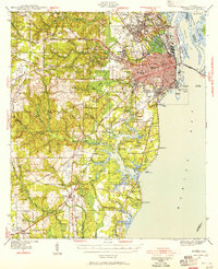 1940 Mobile1955 Print · USGSMobile and its surrounding bayou country appear here just before the mid-century, from the busy State Docks to the quiet reaches of Hollingers Island. Genealogists can locate family landmarks like St Marys Ch, Magnolia Cemetery, and several old rural schools.5 unique versions available
 - 1942 Map of Theodore
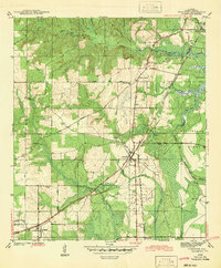 1942 Theodore1942 Print · USGSTheodore and Irvington are shown at the start of the 1940s, highlighting a landscape shaped by historic trails and the bustling Louisville and Nashville Railroad. Researchers can locate family landmarks such as Magnolia Ch, St Elmo-Irvington Sch, and the unique Three Notches settlement.
 - 1943 Map of Theodore
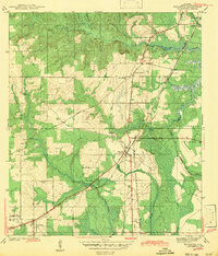 1943 Theodore1943 Print · USGSMobile County during the early 1940s reveals a landscape defined by the intersection of major railroads and coastal wetlands. Researchers can locate community anchors like Three Notches Ch, St Elmo-Irvington Sch, and the rail junction at Theodore.2 unique versions available
 - 1944 Map of Mobile
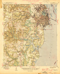 1944 Mobile1944 Print · USGSMobile and its surrounding coastal reaches are captured here during the height of the 1940s. Researchers can trace the city's growth from the dense urban grid out to Spring Hill, locating landmarks like Magnolia Cemetery and the Bankhead Tunnel.4 unique versions available
End of results
Showing maps 1-4 of 4
Top cities near Robinwood
- Mobile historical maps
- Prichard historical maps
- Tillmans Corner historical maps
- Saraland historical maps
- Spanish Fort historical maps
- Chickasaw historical maps
See more
Frequently asked questions
- What are the different types of historical maps available for Robinwood?
- What is the oldest map of Robinwood?
- Where can I purchase historical maps of Robinwood for my home or office?
- Where can I download high-res historical maps of Robinwood?
- Are there historical topographic maps available for Robinwood?
- Is there historical aerial imagery available for Robinwood?
- Where are historical maps of Robinwood sourced from?