1900s (20th Century) Maps of Merrell Beach, Alabama
Explore 8 historic maps of Merrell Beach from the 1900s (20th Century). These maps offer a rare glimpse into what life looked like during the 1900s — showing old roads, neighborhoods, homes, and landmarks that have changed or disappeared over time.
Whether you're researching your family's past, planning a metal detecting trip, or studying how Merrell Beach's landscape evolved across the 1900s, these high-resolution maps are a powerful tool for exploring the history of this region.
- Focus on a specific era: All maps on this page are from the 1900s, giving you a focused view of this time period.
- See what’s changed: Compare century-old streets, trails, and buildings to today's modern landscape using overlays and satellite layers.
- Research with precision: Use these maps for genealogy, historical research, land use analysis, or educational projects.
- View, download, or print: Maps are fully viewable online in high resolution, and can be downloaded or printed for your own records.
Start exploring Merrell Beach's history through authentic maps from the 1900s. This is your window into the past.
Merrell Beach, AL maps
(8)- 1909 Map of Columbiana, 1968 Print
 1909 Columbiana1968 Print · USGSShelby County at the start of the twentieth century was a vital junction for the Southern and L&N railroads. Local researchers can locate family landmarks like Watson Ford, several rural schools including Summer Hill School, and early churches like Lyon Church.
 - 1911 Map of Columbiana
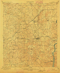 1911 Columbiana1911 Print · USGSCentral Alabama's industrial landscape is captured here just after the first decade of the century, showing a region deeply connected by rail and river. Genealogists can trace family names at Woods Ferry or locate old community hubs like Summer Hill School and Kingdom Church.2 unique versions available
 - 1953 Map of Birmingham, 1964 Print
 1953 Birmingham1964 Print · USGSCentral Alabama at mid-century shows a landscape defined by industrial expansion and the iron-rich ridges surrounding Birmingham. Researchers can trace the extensive rail networks of the L & N RR or locate historic federal sites like the Anniston Ordnance Depot.4 unique versions available
 - 1956 Map of Birmingham
 1956 Birmingham1956 Print · USGSCentral Alabama in the mid-fifties exhibits a landscape of growing cities and deep-rooted industrial corridors. Genealogists and historians can trace the development of suburban Mountain Brook or locate regional hubs like Sylacauga and Jasper.
 - 1957 Map of Birmingham
 1957 Birmingham1957 Print · USGSNorth-Central Alabama in the mid-fifties is an industrial powerhouse centered on the steel valleys and sprawling iron ridges. Genealogists and historians can trace the rail-linked growth of Birmingham and Tuscaloosa, or locate rural landmarks like Talladega College and the Anniston Ordnance Depot.
 - 1975 Map of Columbiana SE, 1977 Print
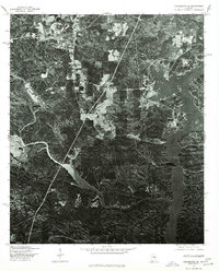 1975 Columbiana SE1977 Print · USGSThe community of Shelby is captured in the mid-seventies as it transitions from the wooded uplands to the winding banks of the Coosa River. Genealogists and local historians can trace the rural road networks and the exact 1970s shoreline of the river valley.
 - 1980 Map of Shelby
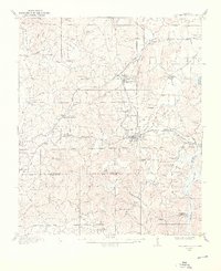
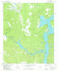 1980 Shelby1980 Print · USGSShelby and the surrounding lakefront are captured here in the early eighties as the town and the Coosa River landscape evolved. Local researchers can trace family landmarks like Brasher Cem and Bay Spring Ch or the winding path of Waxahatchee Creek.2 unique versions available
 - 1984 Map of Birmingham South, 1985 Print
 1984 Birmingham South1985 Print · USGSThe Birmingham metropolitan region and the Coosa River valley are shown here in the mid-eighties as suburban growth expanded south into the ridges. Genealogists and local historians can trace the development of communities from Bessemer to Sylacauga alongside the Lay Lake shoreline and the Talladega National Forest.2 unique versions available
End of results
Showing maps 1-8 of 8
Top cities near Merrell Beach
- Hoover historical maps
- Alabaster historical maps
- Pelham historical maps
- Calera historical maps
- Chelsea historical maps
- Sylacauga historical maps
See more
Frequently asked questions
- What are the different types of historical maps available for Merrell Beach?
- What is the oldest map of Merrell Beach?
- Where can I purchase historical maps of Merrell Beach for my home or office?
- Where can I download high-res historical maps of Merrell Beach?
- Are there historical topographic maps available for Merrell Beach?
- Is there historical aerial imagery available for Merrell Beach?
- Where are historical maps of Merrell Beach sourced from?