1970s Maps of Sulphur Spring, Talladega Springs
Explore 2 historic maps of Sulphur Spring from the 1970s. These maps offer a rare glimpse into what life looked like during the 1970s — showing old roads, neighborhoods, homes, and landmarks that have changed or disappeared over time.
Whether you're researching your family's past, planning a metal detecting trip, or studying how Sulphur Spring's landscape evolved across the 1970s, these high-resolution maps are a powerful tool for exploring the history of this region.
- Focus on a specific era: All maps on this page are from the 1970s, giving you a focused view of this time period.
- See what’s changed: Compare century-old streets, trails, and buildings to today's modern landscape using overlays and satellite layers.
- Research with precision: Use these maps for genealogy, historical research, land use analysis, or educational projects.
- View, download, or print: Maps are fully viewable online in high resolution, and can be downloaded or printed for your own records.
Start exploring Sulphur Spring's history through authentic maps from the 1970s. This is your window into the past.
Sulphur Spring, Talladega Springs maps
(2)- 1975 Map of Gantts Quarry SW, 1977 Print
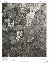 1975 Gantts Quarry SW1977 Print · USGSThe rural landscape of central Alabama comes into focus in the mid-1970s, showing the riverine topography and wooded uplands. Researchers can trace the layout of settlements like Marble Valley and Talladega Springs near the Coosa River.
 - 1979 Map of Talladega Springs, 1980 Print
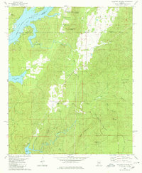 1979 Talladega Springs1980 Print · USGSTalladega Springs and the tri-county borderlands of central Alabama are captured here during the late seventies as the riverfront evolved. Researchers can locate the Talladega Springs Cem, the rural Union Springs Ch, and trace old routes through Marble Valley and Strickland Crossroads.2 unique versions available
End of results
Showing maps 1-2 of 2
Top cities near Sulphur Spring
- Hoover historical maps
- Pelham historical maps
- Calera historical maps
- Chelsea historical maps
- Sylacauga historical maps
- Clanton historical maps
See more
Frequently asked questions
- What are the different types of historical maps available for Sulphur Spring?
- What is the oldest map of Sulphur Spring?
- Where can I purchase historical maps of Sulphur Spring for my home or office?
- Where can I download high-res historical maps of Sulphur Spring?
- Are there historical topographic maps available for Sulphur Spring?
- Is there historical aerial imagery available for Sulphur Spring?
- Where are historical maps of Sulphur Spring sourced from?