1900s (20th Century) Maps of Jasper, Alabama
Explore 12 historic maps of Jasper from the 1900s (20th Century). These maps offer a rare glimpse into what life looked like during the 1900s — showing old roads, neighborhoods, homes, and landmarks that have changed or disappeared over time.
Whether you're researching your family's past, planning a metal detecting trip, or studying how Jasper's landscape evolved across the 1900s, these high-resolution maps are a powerful tool for exploring the history of this region.
- Focus on a specific era: All maps on this page are from the 1900s, giving you a focused view of this time period.
- See what’s changed: Compare century-old streets, trails, and buildings to today's modern landscape using overlays and satellite layers.
- Research with precision: Use these maps for genealogy, historical research, land use analysis, or educational projects.
- View, download, or print: Maps are fully viewable online in high resolution, and can be downloaded or printed for your own records.
Start exploring Jasper's history through authentic maps from the 1900s. This is your window into the past.
Jasper, AL maps
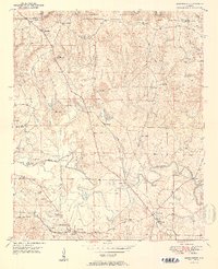
(12)- 1949 Map of Cordova, 1967 Print
 1949 Cordova1967 Print · USGSWalker County during the late 1940s shows a complex network of river bends and rail lines centered on Cordova. Researchers can trace old family settlements and rural landmarks like Gardiners Gin, Wesley Ch, and the crossing at Benoit.4 unique versions available
 - 1949 Map of Jasper, 1969 Print
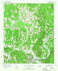
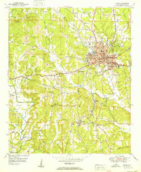
 1949 Jasper1969 Print · USGSWalker County during the mid-century industrial peak reveals a landscape defined by coal and the convergence of major rail lines. Researchers can trace family roots at Oak Hill Cem, locate the old Frisco Quarters, or find the historic Walker County Airport.2 unique versions available
 - 1949 Map of Manchester, 1972 Print
 1949 Manchester1972 Print · USGSWalker County during the late 1940s shows a landscape of small mining and farming settlements connected by the Alabama Central Railroad. Genealogists can locate family landmarks like Old Bennett Cem, Macedonia Sch, and the rural community at Five Points.2 unique versions available
 - 1949 Map of Sunlight, 1973 Print
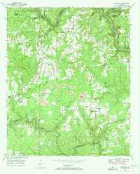 1949 Sunlight1973 Print · USGSWalker County at the end of the 1940s reveals a landscape of winding creek valleys and emerging coal extraction. Researchers can trace family history at sites like Blooming Grove Cem, the settlement of Sunlight, and Philadelphia Ch.3 unique versions available
 - 1950 Map of Manchester
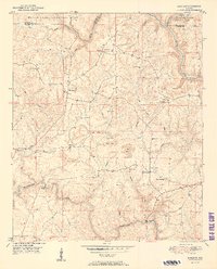
 1950 Manchester1950 Print · USGSWalker County during the mid-century period shows a landscape of rural schoolhouses and forest management just north of Jasper. Researchers can trace the Alabama Central RR (Abandoned) and locate vanished local landmarks like Hudson Settlement and the Bankhead Farmstead Sch.2 unique versions available
 - 1951 Map of Jasper
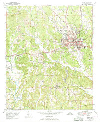
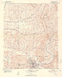
 1951 Jasper1951 Print · USGSJasper and its surrounding coal-country communities are captured in the early 1950s as industry and aviation began to reshape the Walker County landscape. Genealogists and local historians can trace family roots at Oak Hill Cem, visit Snoddy Chapel, or locate schools like Scottsville Sch.2 unique versions available
 - 1951 Map of Cordova
 1951 Cordova1951 Print · USGSWalker County at the start of the 1950s reveals a landscape defined by the Mulberry Fork river and a dense network of competing rail lines. Researchers can trace family roots through numerous local landmarks like Gardiners Gin, Sardis Cem, and the rural Wesley Ch.2 unique versions available
 - 1951 Map of Sunlight
 1951 Sunlight1951 Print · USGSWalker County at mid-century shows a landscape of forest and industry just as mining operations began to mark the terrain. Genealogists can trace family roots through numerous country churches like Mt Joy Ch and quiet burial grounds such as Tidwell Cem.2 unique versions available
 - 1953 Map of Birmingham, 1964 Print
 1953 Birmingham1964 Print · USGSCentral Alabama at mid-century shows a landscape defined by industrial expansion and the iron-rich ridges surrounding Birmingham. Researchers can trace the extensive rail networks of the L & N RR or locate historic federal sites like the Anniston Ordnance Depot.4 unique versions available
 - 1956 Map of Birmingham
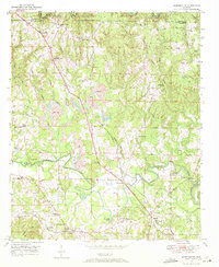
 1956 Birmingham1956 Print · USGSCentral Alabama in the mid-fifties exhibits a landscape of growing cities and deep-rooted industrial corridors. Genealogists and historians can trace the development of suburban Mountain Brook or locate regional hubs like Sylacauga and Jasper.
 - 1957 Map of Birmingham
 1957 Birmingham1957 Print · USGSNorth-Central Alabama in the mid-fifties is an industrial powerhouse centered on the steel valleys and sprawling iron ridges. Genealogists and historians can trace the rail-linked growth of Birmingham and Tuscaloosa, or locate rural landmarks like Talladega College and the Anniston Ordnance Depot.
 - 1984 Map of Jasper, 1985 Print
 1984 Jasper1985 Print · USGSIn the mid-1980s, the Walker County coalfields were a complex web of rail lines and river terminals. Researchers can trace the industrial heritage of the Mulberry Fork and locate local landmarks like the Carbon Hill National Fish Hatchery or Saragossa Ch.2 unique versions available
End of results
Showing maps 1-12 of 12
Top cities near Jasper
- Birmingham historical maps
- Sumiton historical maps
- Dora historical maps
- Carbon Hill historical maps
- Cordova historical maps
- Parrish historical maps
See more
Top neighborhoods of Jasper
- Five Points historical maps
- Hudson Settlement historical maps
- Frisco Quarters historical maps
- Oak Hill historical maps
- Hillsdale historical maps
Frequently asked questions
- What are the different types of historical maps available for Jasper?
- What is the oldest map of Jasper?
- Where can I purchase historical maps of Jasper for my home or office?
- Where can I download high-res historical maps of Jasper?
- Are there historical topographic maps available for Jasper?
- Is there historical aerial imagery available for Jasper?
- Where are historical maps of Jasper sourced from?