Old Maps of Port Moller, Alaska for Metal Detecting
Plan your next treasure hunt with 4 historic maps of Port Moller. Find old homesites, ghost towns, trails, and gathering spots that may be lost to time — perfect for identifying promising metal detecting locations.
- Locate forgotten sites: Uncover places like long-lost settlements, abandoned rail lines, or gathering spots.
- Plan better hunts: Use map overlays combined with LiDAR or satellite views to narrow in on historically rich areas.
- Made for detectorists: Thousands of hobbyists use these maps to discover relics, coins, and hidden history.
Use these historic maps to boost your research and find new opportunities beneath the surface of Port Moller.
Port Moller, AK maps
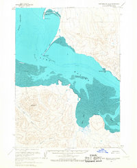
(4)- 1953 Map of Port Moller
 1953 Port Moller1953 Print · USGSThe Alaska Peninsula during the early fifties reveals a maritime landscape of canneries, volcanic peaks, and strategic naval reserves. Researchers can trace remote Cabins, the Nelson Lagoon Cannery, and historical Ruins along the shores of Beaver Bay.3 unique versions available
 - 1963 Map of Port Moller D-2, 1967 Print
 1963 Port Moller D-21967 Print · USGSThe Alaska Peninsula's remote coast is captured here in the mid-1960s, showing the intersection of maritime wilderness and early settlement. Researchers can trace the rugged shoreline from Port Moller past the geothermal Hot Spring to the heights of Staniukovich Mountain.2 unique versions available
 - 1988 Map of Port Moller, 1991 Print
 1988 Port Moller1991 Print · USGSThe remote reaches of the Alaska Peninsula and the Shumagin Islands are detailed here as they appeared in the late twentieth century. Researchers can trace the maritime hubs of Sand Point and Squaw Harbor or find isolated outposts like Nelson Lagoon Village and Miner.
 - 2020 Map of Port Moller D-2 NW, 2020 Print
 2020 Port Moller D-2 NW2020 Print · USGSThe waters of the Alaska Peninsula take center stage in this 2020 coastal survey. Maritime researchers can trace the intricate shorelines of Port Moller and Moller Spit, or navigate the depths of the Hague Channel.
End of results
Showing maps 1-4 of 4
Frequently asked questions
- What are the different types of historical maps available for Port Moller?
- What is the oldest map of Port Moller?
- Where can I purchase historical maps of Port Moller for my home or office?
- Where can I download high-res historical maps of Port Moller?
- Are there historical topographic maps available for Port Moller?
- Is there historical aerial imagery available for Port Moller?
- Where are historical maps of Port Moller sourced from?