Old Maps of Unga, Alaska for Metal Detecting
Plan your next treasure hunt with 5 historic maps of Unga. Find old homesites, ghost towns, trails, and gathering spots that may be lost to time — perfect for identifying promising metal detecting locations.
- Locate forgotten sites: Uncover places like long-lost settlements, abandoned rail lines, or gathering spots.
- Plan better hunts: Use map overlays combined with LiDAR or satellite views to narrow in on historically rich areas.
- Made for detectorists: Thousands of hobbyists use these maps to discover relics, coins, and hidden history.
Use these historic maps to boost your research and find new opportunities beneath the surface of Unga.
Unga, AK maps
(5)- 1953 Map of Port Moller
 1953 Port Moller1953 Print · USGSThe Alaska Peninsula during the early fifties reveals a maritime landscape of canneries, volcanic peaks, and strategic naval reserves. Researchers can trace remote Cabins, the Nelson Lagoon Cannery, and historical Ruins along the shores of Beaver Bay.3 unique versions available
 - 1963 Map of Port Moller A-2, 1967 Print
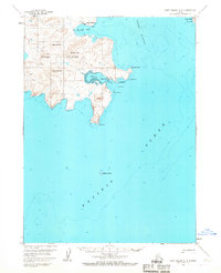 1963 Port Moller A-21967 Print · USGSUnga Island and the surrounding waters of the Shumagin Islands are detailed here in the early sixties, showing the vital maritime connection between remote coastal settlements. Researchers can trace the layout of the Unga townsite and Squaw Harbor, or locate the historic Apollo Mine near the island's interior peaks.3 unique versions available
 - 1988 Map of Port Moller, 1991 Print
 1988 Port Moller1991 Print · USGSThe remote reaches of the Alaska Peninsula and the Shumagin Islands are detailed here as they appeared in the late twentieth century. Researchers can trace the maritime hubs of Sand Point and Squaw Harbor or find isolated outposts like Nelson Lagoon Village and Miner.
 - 2020 Map of Port Moller A-2 NW, 2020 Print
 2020 Port Moller A-2 NW2020 Print · USGSCovers Unga, including Squaw Harbor, Aleutians East, and other nearby areas
 - 2023 Map of Port Moller A-2 NW, 2023 Print
 2023 Port Moller A-2 NW2023 Print · USGSUnga Island and the eastern Shumagin Islands are detailed in this recent survey, capturing the remote coastal geography of the Aleutians East. Trace the historic settlement of Unga near Delarof Harbor and explore landmarks like Apollo Mtn and Unga Cape.
End of results
Showing maps 1-5 of 5
Top cities near Unga
Frequently asked questions
- What are the different types of historical maps available for Unga?
- What is the oldest map of Unga?
- Where can I purchase historical maps of Unga for my home or office?
- Where can I download high-res historical maps of Unga?
- Are there historical topographic maps available for Unga?
- Is there historical aerial imagery available for Unga?
- Where are historical maps of Unga sourced from?