Old Maps of North Pole, Alaska
Explore 18 old maps of North Pole, spanning from 1949 to today. These high-resolution historic maps reveal how streets, neighborhoods, landmarks, and natural features evolved over time — perfect for genealogy, metal detecting, research, and local history exploration.
What you can do with these maps:
- See how North Pole changed over time: Compare historical maps to modern-day views to trace roads, homesites, rail lines & more.
- View detailed metadata: Each map includes creators, publishers, year, scale, and archive source.
- Overlay maps with satellite & LiDAR: Visualize the past alongside modern tools to explore terrain & human change.
- Trusted historical sources: Maps sourced from the USGS, Library of Congress, and other archives.
- Access maps your way: View online, download high-res files, or order prints for personal or research use.
Start exploring old maps of North Pole to uncover forgotten places, hidden landmarks, and the deep history beneath your feet.
North Pole, AK maps
(18)- 1949 Map of Fairbanks D-1
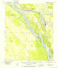
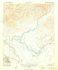 1949 Fairbanks D-11949 Print · USGSInterior Alaska at the close of the 1940s reveals a landscape defined by gold-stream drainages and the early road network south of the hills. Trace the winding Chena Slough and the tracks of the Alaska Railroad as they parallel the Richardson Highway.7 unique versions available
 - 1949 Map of Fairbanks C-1, 1958 Print
 1949 Fairbanks C-11958 Print · USGSDuring the early Cold War, this Alaska territory was defined by massive military installations and the braided Tanana River. Trace the early footprint of Eielson Air Force Base and the legacy transport corridor of the Alaska Railroad.
 - 1950 Map of Fairbanks, 1955 Print
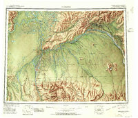 1950 Fairbanks1955 Print · USGSMid-century Interior Alaska centers on the growing hub of Fairbanks and the massive military infrastructure that reshaped the region. Trace the path of the Alaska Railroad past remote stops like Nenana and Dunbar, or locate early aviation and mining landmarks such as Weeks Field and various Placer Mine sites.2 unique versions available
 - 1950 Map of Fairbanks C-1, 1964 Print
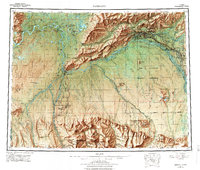
 1950 Fairbanks C-11964 Print · USGSThe Tanana River valley was a hub of Cold War defense and transport in the 1950s. Researchers can trace the early layout of Eielson Air Force Base and the critical corridor formed by the Richardson Highway and The Alaska Railroad.4 unique versions available
 - 1951 Map of Fairbanks
 1951 Fairbanks1951 Print · USGSThe Interior of Alaska at the height of the mid-century military buildup shows a landscape of strategic airfields and remote river settlements. Researchers can trace the path of the Alaska Railroad and locate cold-war era sites like Ladd Air Force Base and Minto.2 unique versions available
 - 1952 Map of Fairbanks C-1
 1952 Fairbanks C-11952 Print · USGSThe Tanana River Valley was a hub of military and transport growth in the early fifties. You can trace the footprint of Eielson Air Force Base alongside the Alaska Railroad and the historic Richardson Highway through Big Horn.2 unique versions available
 - 1952 Map of Fairbanks D-1
 1952 Fairbanks D-11952 Print · USGSInterior Alaska's river systems and early transport corridors are documented here in the early fifties. Researchers can trace historical routes like the Iowa Sled Road, the path of the Alaska Railroad, and family landmarks such as Lakloey Hill.
 - 1952 Map of Fairbanks, 1958 Print
 1952 Fairbanks1958 Print · USGSAlaska's interior undergoes a post-war transformation as military installations and rail lines expand across the Tanana Valley. Genealogists and historians can trace the early layout of North Pole, the operations at Ester, and the course of The Alaska Railroad.6 unique versions available
 - 1956 Map of Fairbanks, 1978 Print
 1956 Fairbanks1978 Print · USGSIn the mid-twentieth century, the Fairbanks region emerged as a critical Cold War interior hub. Researchers can trace the expansion of Fairbanks, the rail yards of The Alaska Railroad, and military landmarks like Eielson AFB.3 unique versions available
 - 1964 Map of Fairbanks
 1964 Fairbanks1964 Print · USGSInterior Alaska in the mid-1960s centered on the growing hub of Fairbanks and its strategic military and rail connections. Genealogists and historians can trace the paths of The Alaska Railroad through Nenana or locate Placer Mines near Murphy Dome and Ester.
 - 1966 Map of Fairbanks D-1 SW, 1970 Print
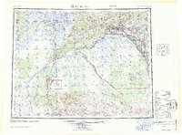
 1966 Fairbanks D-1 SW1970 Print · USGSThe Fairbanks area in the mid-sixties reveals a landscape defined by meandering rivers and growing military and civilian infrastructure. Local historians can trace early developments at North Pole and Highland Park or locate aviation landmarks like the Bradley Sky Ranch.2 unique versions available
 - 1992 Map of Fairbanks D-1 SW
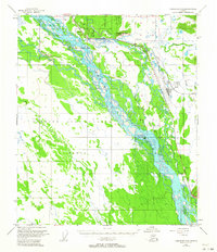
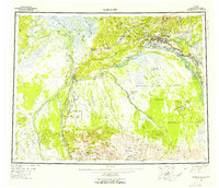
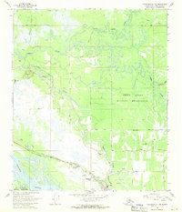
 1992 Fairbanks D-1 SW1992 Print · USGSFairbanks North Star Borough comes into focus during the early nineties as residential life and industrial infrastructure expand along the Chena River. Genealogists and historians can trace the development of North Pole, identify local institutions like Badger Road Sch, and follow the route of the Trans-Alaska Pipeline.
 - 1992 Map of Fairbanks C-1 NW
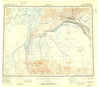
 1992 Fairbanks C-1 NW1992 Print · USGSThe community of North Pole and the Tanana River valley are shown here in the early nineties during a period of significant infrastructure development. Researchers can trace the path of the Trans-Alaska Pipeline past the Refinery and through the Dyke Range Military Reservation.
 - 2016 Map of Fairbanks D-1 SW, 2016 Print
 2016 Fairbanks D-1 SW2016 Print · USGSCovers North Pole, including Badger, Highland Park, and other nearby areas
 - 2016 Map of Fairbanks C-1 NW, 2016 Print
 2016 Fairbanks C-1 NW2016 Print · USGSCovers North Pole, including Fairbanks North Star, United States, and other nearby areas
 - 2021 Map of Fairbanks C-1 NW, 2021 Print
 2021 Fairbanks C-1 NW2021 Print · USGSThe community of North Pole is captured in the early 2020s, showing a mix of residential expansion and critical energy infrastructure. Researchers can trace the path of the Alaska Pipeline and locate local landmarks such as Howards Airport and Chena Slough.
 - 2021 Map of Fairbanks D-1 SW, 2021 Print
 2021 Fairbanks D-1 SW2021 Print · USGSCovers North Pole, including Badger, Highland Park, and other nearby areas
 - 2024 Map of Fairbanks D-1 SW, 2024 Print
 2024 Fairbanks D-1 SW2024 Print · USGSNorth Pole and the surrounding river corridors appear here in modern detail, illustrating the intersection of natural waterways and major energy infrastructure. Researchers can trace the path of the Alaska Pipeline as it passes near Badger and locate several regional airfields like Bradley Sky-Ranch Airport.
End of results
Showing maps 1-18 of 18
Top cities near North Pole
Top neighborhoods of North Pole
Frequently asked questions
- What are the different types of historical maps available for North Pole?
- What is the oldest map of North Pole?
- Where can I purchase historical maps of North Pole for my home or office?
- Where can I download high-res historical maps of North Pole?
- Are there historical topographic maps available for North Pole?
- Is there historical aerial imagery available for North Pole?
- Where are historical maps of North Pole sourced from?