Old Maps of Tanani, Alaska
Explore 5 old maps of Tanani, spanning from 1952 to today. These high-resolution historic maps reveal how streets, neighborhoods, landmarks, and natural features evolved over time — perfect for genealogy, metal detecting, research, and local history exploration.
What you can do with these maps:
- See how Tanani changed over time: Compare historical maps to modern-day views to trace roads, homesites, rail lines & more.
- View detailed metadata: Each map includes creators, publishers, year, scale, and archive source.
- Overlay maps with satellite & LiDAR: Visualize the past alongside modern tools to explore terrain & human change.
- Trusted historical sources: Maps sourced from the USGS, Library of Congress, and other archives.
- Access maps your way: View online, download high-res files, or order prints for personal or research use.
Start exploring old maps of Tanani to uncover forgotten places, hidden landmarks, and the deep history beneath your feet.
Tanani, AK maps
(5)- 1952 Map of Skagway, 1953 Print
 1952 Skagway1953 Print · USGSThe northern reaches of the Alaska Panhandle come alive in the early fifties, showing the vital rail and road links to the Yukon. Trace the historic White Pass & Yukon Route or locate remote camps like Pleasant Camp and Klukwan.4 unique versions available
 - 1954 Map of Skagway B-2, 1959 Print
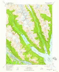 1954 Skagway B-21959 Print · USGSThe Lynn Canal region of Alaska was a landscape of maritime navigation and glacial mountain passes in the mid-fifties. Genealogists and historians can trace the early footprint of the Yindastuki Indian Res and coastal sites like Tanani and Chilkoot.4 unique versions available
 - 1961 Map of Skagway, 1967 Print
 1961 Skagway1967 Print · USGSThe northern reaches of the Panhandle and the rugged border with British Columbia come into focus in the early sixties. Researchers can trace the historic Chilkoot Trail, the White Pass and Yukon Railway, and coastal outposts like Klukwan.4 unique versions available
 - 1991 Map of Skagway B-2 SE
 1991 Skagway B-2 SE1991 Print · USGSThe northern Alaskan coast near Haines comes into focus in the early nineties, showing a landscape defined by deep inlets and military infrastructure. Researchers can trace local landmarks like the Haines Fuel Terminal, the Ferry Dock, and the settlement at Tanani.
 - 2017 Map of Skagway B-2 SE, 2017 Print
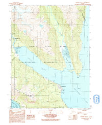
 2017 Skagway B-2 SE2017 Print · USGSThe coastal corridor near the Upper Lynn Canal comes into focus in this recent survey of the Southeast Alaska panhandle. Genealogists and local historians can trace the roads and shorelines connecting Haines and Tanani, from Mt Ripinski down to the waters of Lutak Inlet.
End of results
Showing maps 1-5 of 5
Top cities near Tanani
Frequently asked questions
- What are the different types of historical maps available for Tanani?
- What is the oldest map of Tanani?
- Where can I purchase historical maps of Tanani for my home or office?
- Where can I download high-res historical maps of Tanani?
- Are there historical topographic maps available for Tanani?
- Is there historical aerial imagery available for Tanani?
- Where are historical maps of Tanani sourced from?