Old Maps of Hawk Inlet, Alaska for Metal Detecting
Plan your next treasure hunt with 8 historic maps of Hawk Inlet. Find old homesites, ghost towns, trails, and gathering spots that may be lost to time — perfect for identifying promising metal detecting locations.
- Locate forgotten sites: Uncover places like long-lost settlements, abandoned rail lines, or gathering spots.
- Plan better hunts: Use map overlays combined with LiDAR or satellite views to narrow in on historically rich areas.
- Made for detectorists: Thousands of hobbyists use these maps to discover relics, coins, and hidden history.
Use these historic maps to boost your research and find new opportunities beneath the surface of Hawk Inlet.
Hawk Inlet, AK maps
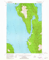
(8)- 1948 Map of Juneau A-3, 1956 Print
 1948 Juneau A-31956 Print · USGSAdmiralty Island in the late 1940s was a hub of remote industry and rugged coastal activity. Researchers can trace the maritime infrastructure of the Hawk Inlet Cannery or locate isolated resource sites like the Admiralty Mine and its hillside Tramway.
 - 1950 Map of Juneau A-3, 1964 Print
 1950 Juneau A-31964 Print · USGSThe maritime wilderness of the Mansfield Peninsula is captured here in the 1950s, showing a landscape defined by salmon processing and mining. Researchers can trace the industrial footprint of the Hawk Inlet Cannery, the aviation history at the Seaplane Base, and the upland Tramway near Robert Barron Peak.3 unique versions available
 - 1951 Map of Juneau
 1951 Juneau1951 Print · USGSJuneau and the industrial waterfront of the Gastineau Channel are shown here at the start of the 1950s. Researchers can trace the mid-century footprint of Juneau, the mining history of Treadwell, and remote maritime outposts like Hoonah and Gustavus.4 unique versions available
 - 1962 Map of Juneau, 1966 Print
 1962 Juneau1966 Print · USGSSoutheast Alaska in the early sixties showcases a maritime landscape defined by the Tongass National Forest and the peaks of the Coast Mountains. Trace the footprints of coastal industry at Treadwell, Thane, and the regional hub of Juneau.7 unique versions available
 - 1997 Map of Juneau A-3, 2000 Print
 1997 Juneau A-32000 Print · USGSThe maritime crossroads of Southeast Alaska are captured here in the late twentieth century, showing the rugged intersection of industrial mining and wilderness preservation. Trace the shorelines of Funter Bay and Hawk Inlet to find the Admiralty Mine and isolated Cabins.
 - 2017 Map of Juneau A-3 NE, 2017 Print
 2017 Juneau A-3 NE2017 Print · USGSCovers Hawk Inlet, including Unorganized Borough, Juneau, and other nearby areas
 - 2021 Map of Juneau A-3 NE, 2021 Print
 2021 Juneau A-3 NE2021 Print · USGSCovers Hawk Inlet, including Unorganized Borough, Juneau, and other nearby areas
 - 2024 Map of Juneau A-3 NE, 2024 Print
 2024 Juneau A-3 NE2024 Print · USGSThe Mansfield Peninsula's coastal wilderness is captured in the 2020s, showing the intersection of the Tongass National Forest and industrial access. Researchers can trace the path of Green's Creek "A" Road and locate remote landmarks like False Arden and Snowy Mtn.
End of results
Showing maps 1-8 of 8
Frequently asked questions
- What are the different types of historical maps available for Hawk Inlet?
- What is the oldest map of Hawk Inlet?
- Where can I purchase historical maps of Hawk Inlet for my home or office?
- Where can I download high-res historical maps of Hawk Inlet?
- Are there historical topographic maps available for Hawk Inlet?
- Is there historical aerial imagery available for Hawk Inlet?
- Where are historical maps of Hawk Inlet sourced from?