Old Maps of Nikolaevsk, Alaska
Explore 8 old maps of Nikolaevsk, spanning from 1946 to today. These high-resolution historic maps reveal how streets, neighborhoods, landmarks, and natural features evolved over time — perfect for genealogy, metal detecting, research, and local history exploration.
What you can do with these maps:
- See how Nikolaevsk changed over time: Compare historical maps to modern-day views to trace roads, homesites, rail lines & more.
- View detailed metadata: Each map includes creators, publishers, year, scale, and archive source.
- Overlay maps with satellite & LiDAR: Visualize the past alongside modern tools to explore terrain & human change.
- Trusted historical sources: Maps sourced from the USGS, Library of Congress, and other archives.
- Access maps your way: View online, download high-res files, or order prints for personal or research use.
Start exploring old maps of Nikolaevsk to uncover forgotten places, hidden landmarks, and the deep history beneath your feet.
Nikolaevsk, AK maps
(8)- 1946 Map of Seldovia D-5, 1958 Print
 1946 Seldovia D-51958 Print · USGSThe Kenai Peninsula coastline comes into focus just after the war as the modern road network begins to take shape. Researchers can trace the early layout of Anchor Point and identify coastal landmarks like Cape Starichkof and the Sterling Highway.
 - 1951 Map of Seldovia D-5
 1951 Seldovia D-51951 Print · USGSThe Kenai Peninsula coastline during the early fifties shows a burgeoning frontier landscape connected by the new Sterling Highway. Researchers can trace the layout of Anchor Point, the local Airstrip, and several major salmon streams like Deep Creek and the Stariski River.
 - 1951 Map of Seldovia, 1952 Print
 1951 Seldovia1952 Print · USGSThe lower Kenai Peninsula appears here in the early fifties as a network of coastal outposts and maritime landing sites. Researchers can trace early settlements like Seldovia, locate family-named points such as Millers Landing, and explore the limits of the Kenai National Moose Range.8 unique versions available
 - 1961 Map of Seldovia D-5, 1962 Print
 1961 Seldovia D-51962 Print · USGSThe Kenai Peninsula coastline comes into focus in the early sixties as new roads and settlements began to define the region. You can trace early coastal developments like Whiskey Gulch, the Airstrip at Anchor Point, and the path of the Sterling Highway.2 unique versions available
 - 1963 Map of Seldovia, 1967 Print
 1963 Seldovia1967 Print · USGSThe lower Kenai Peninsula in the 1960s reveals a rugged coastal frontier where the highway finally meets the sea at Homer. Researchers can trace old settlements and family sites at Happy Valley, Stariski, and the Indian Village near Seldovia.5 unique versions available
 - 1987 Map of Seldovia D-5 SE
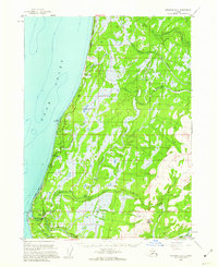
 1987 Seldovia D-5 SE1987 Print · USGSThe Kenai Peninsula's rural interior comes into focus during the 1980s, centered on the Russian Old Believer settlements. Researchers can trace the early footprints of Nikolaevsk and Nahodka or follow the path of the Winter Trail and Anchor River.
 - 2014 Map of Seldovia D-5 SE, 2014 Print
 2014 Seldovia D-5 SE2014 Print · USGSCovers Nikolaevsk, including Kluchevaya, Nahodka, and other nearby areas
 - 2024 Map of Seldovia D-5 SE, 2024 Print
 2024 Seldovia D-5 SE2024 Print · USGSThe rural communities and river valleys of the Kenai Peninsula are captured here in the early twenty-first century. Genealogists and local historians can trace the development of Nikolaevsk and find landmarks like Epperson Knob or the historic Wagon Road (Epic).
End of results
Showing maps 1-8 of 8
Top cities near Nikolaevsk
Frequently asked questions
- What are the different types of historical maps available for Nikolaevsk?
- What is the oldest map of Nikolaevsk?
- Where can I purchase historical maps of Nikolaevsk for my home or office?
- Where can I download high-res historical maps of Nikolaevsk?
- Are there historical topographic maps available for Nikolaevsk?
- Is there historical aerial imagery available for Nikolaevsk?
- Where are historical maps of Nikolaevsk sourced from?