Old Maps of Kokhanok, Alaska
Explore 5 old maps of Kokhanok, spanning from 1951 to today. These high-resolution historic maps reveal how streets, neighborhoods, landmarks, and natural features evolved over time — perfect for genealogy, metal detecting, research, and local history exploration.
What you can do with these maps:
- See how Kokhanok changed over time: Compare historical maps to modern-day views to trace roads, homesites, rail lines & more.
- View detailed metadata: Each map includes creators, publishers, year, scale, and archive source.
- Overlay maps with satellite & LiDAR: Visualize the past alongside modern tools to explore terrain & human change.
- Trusted historical sources: Maps sourced from the USGS, Library of Congress, and other archives.
- Access maps your way: View online, download high-res files, or order prints for personal or research use.
Start exploring old maps of Kokhanok to uncover forgotten places, hidden landmarks, and the deep history beneath your feet.
Kokhanok, AK maps
(5)- 1951 Map of Iliamna B-5, 1956 Print
 1951 Iliamna B-51956 Print · USGSThe Lake and Peninsula region at mid-century reveals a remote landscape of subsistence outposts and glacial waters. Local historians can trace the footprint of the Reindeer Station (Aband) and seasonal dwellings near Kakhonak and Sid Larson Bay.
 - 1952 Map of Iliamna, 1953 Print
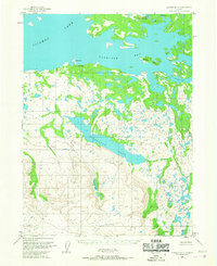
 1952 Iliamna1953 Print · USGSAlaska's interior and coastline meet in this early 1950s survey of the Lake Iliamna region. Researchers can trace remote settlements and camps such as Fish Village, Old Iliamna (Aband), and Hammerly Camp at the edge of the Katmai National Monument.4 unique versions available
 - 1954 Map of Iliamna B-5, 1967 Print
 1954 Iliamna B-51967 Print · USGSThe southern shores of Iliamna Lake come into focus in the mid-1950s, showing the early infrastructure of the Alaska Peninsula. Researchers can trace the layout of Kakhonak and locate remote outposts like the Landing Area and various Cabins.2 unique versions available
 - 1957 Map of Iliamna, 1965 Print
 1957 Iliamna1965 Print · USGSSouthwestern Alaska in the late fifties centers on the massive waters of Iliamna Lake and its surrounding villages. Trace family roots and old routes at Old Roadhouse, Newhalen, and the Kamishak (Site) near the edge of Katmai National Monument.7 unique versions available
 - 2018 Map of Iliamna B-5 NW, 2018 Print
 2018 Iliamna B-5 NW2018 Print · USGSKokhanok sits on the southern shore of Iliamna Lake in the twenty-first century, defined by its remote airfield and local roads. Trace the community layout around Kokhanok, from the Kokhanok Airport to the shores of Gibraltar Lake.
End of results
Showing maps 1-5 of 5
Frequently asked questions
- What are the different types of historical maps available for Kokhanok?
- What is the oldest map of Kokhanok?
- Where can I purchase historical maps of Kokhanok for my home or office?
- Where can I download high-res historical maps of Kokhanok?
- Are there historical topographic maps available for Kokhanok?
- Is there historical aerial imagery available for Kokhanok?
- Where are historical maps of Kokhanok sourced from?