1950s Maps of Alvamar Park, Matanuska-Susitna
Explore 3 historic maps of Alvamar Park from the 1950s. These maps offer a rare glimpse into what life looked like during the 1950s — showing old roads, neighborhoods, homes, and landmarks that have changed or disappeared over time.
Whether you're researching your family's past, planning a metal detecting trip, or studying how Alvamar Park's landscape evolved across the 1950s, these high-resolution maps are a powerful tool for exploring the history of this region.
- Focus on a specific era: All maps on this page are from the 1950s, giving you a focused view of this time period.
- See what’s changed: Compare century-old streets, trails, and buildings to today's modern landscape using overlays and satellite layers.
- Research with precision: Use these maps for genealogy, historical research, land use analysis, or educational projects.
- View, download, or print: Maps are fully viewable online in high resolution, and can be downloaded or printed for your own records.
Start exploring Alvamar Park's history through authentic maps from the 1950s. This is your window into the past.
Alvamar Park, Matanuska-Susitna maps
(3)- 1951 Map of Anchorage
 1951 Anchorage1951 Print · USGSMid-century Anchorage and the Matanuska Valley are seen here during a period of rapid strategic growth. Trace the development of Fort Richardson, early rail stops at Wasilla, and established mining operations like the Independence Mine or Premier Mine.4 unique versions available
 - 1952 Map of Anchorage B-8, 1965 Print
 1952 Anchorage B-81965 Print · USGSNorth of Anchorage in the early fifties, the landscape transitions from the historic Iditarod Trail at Knik to the rising military infrastructure of Elmendorf Air Force Base. Trace early transportation routes like the Alaska Railroad and Glenn Highway as they cross the Eagle River Flats.
 - 1953 Map of Anchorage B-8, 1954 Print
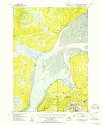 1953 Anchorage B-81954 Print · USGSThe Knik Arm and upper Cook Inlet region show a mix of historic dog-team routes and Cold War military growth in the early fifties. You can trace the Iditarod Trail near Knik or locate early landmarks like Sandpiper Lodge and the Kermit Roosevelt Memorial Cem.2 unique versions available
End of results
Showing maps 1-3 of 3
Frequently asked questions
- What are the different types of historical maps available for Alvamar Park?
- What is the oldest map of Alvamar Park?
- Where can I purchase historical maps of Alvamar Park for my home or office?
- Where can I download high-res historical maps of Alvamar Park?
- Are there historical topographic maps available for Alvamar Park?
- Is there historical aerial imagery available for Alvamar Park?
- Where are historical maps of Alvamar Park sourced from?