Old Maps of Chickaloon, Alaska
Explore 8 old maps of Chickaloon, spanning from 1948 to today. These high-resolution historic maps reveal how streets, neighborhoods, landmarks, and natural features evolved over time — perfect for genealogy, metal detecting, research, and local history exploration.
What you can do with these maps:
- See how Chickaloon changed over time: Compare historical maps to modern-day views to trace roads, homesites, rail lines & more.
- View detailed metadata: Each map includes creators, publishers, year, scale, and archive source.
- Overlay maps with satellite & LiDAR: Visualize the past alongside modern tools to explore terrain & human change.
- Trusted historical sources: Maps sourced from the USGS, Library of Congress, and other archives.
- Access maps your way: View online, download high-res files, or order prints for personal or research use.
Start exploring old maps of Chickaloon to uncover forgotten places, hidden landmarks, and the deep history beneath your feet.
Chickaloon, AK maps
(8)- 1948 Map of Anchorage D-4, 1962 Print
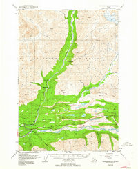 1948 Anchorage D-41962 Print · USGSThe Matanuska River valley in the late 1940s shows a landscape of early highway development and mountain outposts. Trace the old Chickaloon Knik Nelchina Trail or locate remote landmarks like Eightmile Cabin and the Coal Mine (Aban'd).4 unique versions available
 - 1951 Map of Anchorage
 1951 Anchorage1951 Print · USGSMid-century Anchorage and the Matanuska Valley are seen here during a period of rapid strategic growth. Trace the development of Fort Richardson, early rail stops at Wasilla, and established mining operations like the Independence Mine or Premier Mine.4 unique versions available
 - 1952 Map of Anchorage D-4
 1952 Anchorage D-41952 Print · USGSThe Matanuska Valley was a rugged frontier of coal mining and mountain trails in the early fifties. Local historians can trace the early industrial footprint of the Coal Mine (Aban'd) and remote outposts like Ninemile Cabin and the Chickaloon Roadhouse.2 unique versions available
 - 1962 Map of Anchorage, 1966 Print
 1962 Anchorage1966 Print · USGSThe Anchorage bowl and Matanuska Valley appear in this mid-century survey during a period of significant military and industrial expansion. Researchers can trace the Alaska Railroad through Sutton and Jonesville or locate historic stops like Meekins Roadhouse and the Watertower Inn.6 unique versions available
 - 1979 Map of Anchorage, 1980 Print
 1979 Anchorage1980 Print · USGSThe Anchorage bowl and Matanuska Valley appear in the late seventies as the region's transportation and military infrastructure matured. Genealogists and historians can trace rail and road evolution through Wasilla, the Matanuska Branch line, and Jonesville.
 - 1994 Map of Anchorage D-4, 2001 Print
 1994 Anchorage D-42001 Print · USGSThe Matanuska Valley and its surrounding peaks were being meticulously mapped in the 1990s as modern access expanded into the interior. Researchers can trace the Knik Nelchina Trail and locate remote outposts like Ninemile Cabin and the Ninety-eight Bridge.
 - 2016 Map of Anchorage D-4 SW, 2016 Print
 2016 Anchorage D-4 SW2016 Print · USGSCovers Chickaloon, including Matanuska-Susitna, United States, and other nearby areas
 - 2023 Map of Anchorage D-4 SW, 2023 Print
 2023 Anchorage D-4 SW2023 Print · USGSThe Matanuska Valley comes into sharp focus in this recent survey of the area surrounding Chickaloon. Researchers can trace the modern development of the Glenn Highway corridor and locate local landmarks like the King Ranch Airport and Bonnie Lake.
End of results
Showing maps 1-8 of 8
Frequently asked questions
- What are the different types of historical maps available for Chickaloon?
- What is the oldest map of Chickaloon?
- Where can I purchase historical maps of Chickaloon for my home or office?
- Where can I download high-res historical maps of Chickaloon?
- Are there historical topographic maps available for Chickaloon?
- Is there historical aerial imagery available for Chickaloon?
- Where are historical maps of Chickaloon sourced from?