Old Maps of Colorado, Alaska for Genealogy
Trace your family roots with 6 historic maps of Colorado. These high-res maps reveal old neighborhoods, homesites, landmarks, and streets — helping you uncover where your ancestors lived and how the area evolved over time.
- Explore historic neighborhoods: Identify where your relatives may have lived in the 1800s or 1900s.
- Compare maps over time: Trace the changes in streets, buildings, and landmarks for multi-generational research.
- Perfect for genealogy & ancestry research: Used by family historians and researchers to map out lineage and migration.
These maps are an incredible resource for exploring your personal connection to Colorado's past.
Colorado, AK maps
(6)- 1950 Map of Healy A-5, 1965 Print
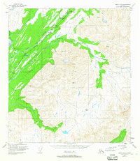 1950 Healy A-51965 Print · USGSThe Alaska interior at mid-century is defined by the vital Alaska Railroad corridor through the Chulitna River valley. Researchers can trace remote mountain infrastructure and early settlements like Colorado, Broad Pass, and the transit points around Honolulu Pass.4 unique versions available
 - 1951 Map of Healy
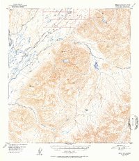
 1951 Healy1951 Print · USGSThe Alaska interior during the early fifties reveals a landscape shaped by the Alaska Railroad and the mining of the Alaska Range. Trace early settlements and infrastructure like Suntrana, the Dunkle Coal Mine, and the McKinley Park Airstrip at the edge of the wilderness.5 unique versions available
 - 1952 Map of Healy A-5
 1952 Healy A-51952 Print · USGSThe Alaska interior at the midpoint of the twentieth century is defined here by the thin line of The Alaska Railroad cutting through the mountains. Researchers can trace the rail corridor through Colorado and Broad Pass, locating remote landmarks like the Airstrip and Honolulu Pass.2 unique versions available
 - 1956 Map of Healy, 1966 Print
 1956 Healy1966 Print · USGSThe interior of Alaska is shown during a period of industrial and recreational expansion in the mid-fifties. Genealogists and historians can trace the Alaska Railroad corridor through Healy and mining sites like Usibelli Mine.4 unique versions available
 - 2016 Map of Healy A-5 NW, 2016 Print
 2016 Healy A-5 NW2016 Print · USGSCovers Colorado, including Matanuska-Susitna, United States, and other nearby areas
 - 2024 Map of Healy A-5 NW, 2024 Print
 2024 Healy A-5 NW2024 Print · USGSThe Matanuska-Susitna Borough interior is documented here in the 2020s, focusing on the high mountain transit corridor through Broad Pass. Local historians can trace the paths of the Parks Highway and Colorado Station Road as they parallel the Middle Fork Chulitna River.
End of results
Showing maps 1-6 of 6
Frequently asked questions
- What are the different types of historical maps available for Colorado?
- What is the oldest map of Colorado?
- Where can I purchase historical maps of Colorado for my home or office?
- Where can I download high-res historical maps of Colorado?
- Are there historical topographic maps available for Colorado?
- Is there historical aerial imagery available for Colorado?
- Where are historical maps of Colorado sourced from?