Old Maps of Palmer, Alaska for Genealogy
Trace your family roots with 12 historic maps of Palmer. These high-res maps reveal old neighborhoods, homesites, landmarks, and streets — helping you uncover where your ancestors lived and how the area evolved over time.
- Explore historic neighborhoods: Identify where your relatives may have lived in the 1800s or 1900s.
- Compare maps over time: Trace the changes in streets, buildings, and landmarks for multi-generational research.
- Perfect for genealogy & ancestry research: Used by family historians and researchers to map out lineage and migration.
These maps are an incredible resource for exploring your personal connection to Palmer's past.
Palmer, AK maps
(12)- 1951 Map of Anchorage
 1951 Anchorage1951 Print · USGSMid-century Anchorage and the Matanuska Valley are seen here during a period of rapid strategic growth. Trace the development of Fort Richardson, early rail stops at Wasilla, and established mining operations like the Independence Mine or Premier Mine.4 unique versions available
 - 1951 Map of Anchorage C-6, 1952 Print
 1951 Anchorage C-61952 Print · USGSThe Matanuska Valley coal fields and early rail network are in full operation during the early fifties. Local historians can trace mining spurs of The Alaska Railroad to sites like Evan Jones Mine and the settlement of Sutton.7 unique versions available
 - 1962 Map of Anchorage, 1966 Print
 1962 Anchorage1966 Print · USGSThe Anchorage bowl and Matanuska Valley appear in this mid-century survey during a period of significant military and industrial expansion. Researchers can trace the Alaska Railroad through Sutton and Jonesville or locate historic stops like Meekins Roadhouse and the Watertower Inn.6 unique versions available
 - 1979 Map of Anchorage C-6 NW
 1979 Anchorage C-6 NW1979 Print · USGSThe Matanuska Valley at the end of the 1970s shows a landscape defined by industrial heritage and a growing road network. Genealogists and historians can trace the Old Grade Railroad and mining sites like the Premier Mine and local Quarries.2 unique versions available
 - 1979 Map of Anchorage, 1980 Print
 1979 Anchorage1980 Print · USGSThe Anchorage bowl and Matanuska Valley appear in the late seventies as the region's transportation and military infrastructure matured. Genealogists and historians can trace rail and road evolution through Wasilla, the Matanuska Branch line, and Jonesville.
 - 1979 Map of Anchorage C-6 SW, 1980 Print
 1979 Anchorage C-6 SW1980 Print · USGSThe Matanuska Valley comes into focus in the late 1970s, showcasing the civic growth of the region around Palmer. Researchers can trace old transportation routes like the Old Railroad Grade and explore local landmarks from the State Fairground to the Community College.2 unique versions available
 - 1992 Map of Anchorage C-6 SW
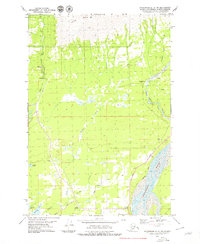
 1992 Anchorage C-6 SW1992 Print · USGSThe Matanuska Valley's development is documented in the early nineties as the community around Palmer continued to grow. Researchers can trace the layout of the University of Alaska Experimental Farm, locate the Palmer Pioneer Cemetery, and follow the Old Railroad Grade.
 - 1994 Map of Anchorage C-6, 2002 Print
 1994 Anchorage C-62002 Print · USGSThe Matanuska Valley in the mid-nineties shows the evolving landscape of Southcentral Alaska as it balances its mining roots with modern growth. Researchers can locate vanished coal operations like the Jonesville Mine or trace the development of Palmer and Butte.
 - 2016 Map of Anchorage C-6 NW, 2016 Print
 2016 Anchorage C-6 NW2016 Print · USGSCovers Palmer, including Matanuska-Susitna, United States, and other nearby areas
 - 2016 Map of Anchorage C-6 SW, 2016 Print
 2016 Anchorage C-6 SW2016 Print · USGSCovers Palmer, including Matanuska, Gateway, and other nearby areas
 - 2023 Map of Anchorage C-6 SW, 2023 Print
 2023 Anchorage C-6 SW2023 Print · USGSThe Matanuska Valley area in the early 2020s exhibits a blend of municipal growth and classic Alaskan aviation culture. Researchers can trace local development around Palmer, the Pioneer Cem, and the many lakes like Baird Lake and Matanuska Lake.
 - 2023 Map of Anchorage C-6 NW, 2023 Print
 2023 Anchorage C-6 NW2023 Print · USGSThe Matanuska Valley meets the Talkeetna Mountains in this recent look at a developing Alaskan landscape. Trace local settlement from North Lakes to Fishhook, and follow the winding Little Susitna River past Arkose Ridge.
End of results
Showing maps 1-12 of 12
Top cities near Palmer
Frequently asked questions
- What are the different types of historical maps available for Palmer?
- What is the oldest map of Palmer?
- Where can I purchase historical maps of Palmer for my home or office?
- Where can I download high-res historical maps of Palmer?
- Are there historical topographic maps available for Palmer?
- Is there historical aerial imagery available for Palmer?
- Where are historical maps of Palmer sourced from?