Old Maps of Nuiqsut, Alaska
Explore 5 old maps of Nuiqsut, spanning from 1951 to today. These high-resolution historic maps reveal how streets, neighborhoods, landmarks, and natural features evolved over time — perfect for genealogy, metal detecting, research, and local history exploration.
What you can do with these maps:
- See how Nuiqsut changed over time: Compare historical maps to modern-day views to trace roads, homesites, rail lines & more.
- View detailed metadata: Each map includes creators, publishers, year, scale, and archive source.
- Overlay maps with satellite & LiDAR: Visualize the past alongside modern tools to explore terrain & human change.
- Trusted historical sources: Maps sourced from the USGS, Library of Congress, and other archives.
- Access maps your way: View online, download high-res files, or order prints for personal or research use.
Start exploring old maps of Nuiqsut to uncover forgotten places, hidden landmarks, and the deep history beneath your feet.
Nuiqsut, AK maps
(5)- 1951 Map of Harrison Bay
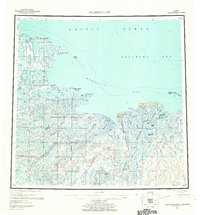
 1951 Harrison Bay1951 Print · USGSThe North Slope of Alaska during the early postwar period reveals a wilderness of massive river deltas and federal petroleum reserves. Researchers can trace the remote waterways of the Colville River and find isolated landmarks like the Trading Post and Ocean Point.
 - 1955 Map of Harrison Bay, 1961 Print
 1955 Harrison Bay1961 Print · USGSThe Arctic coastline of the North Slope appears here in the mid-1950s, centered on the expansive delta of the Colville River. Researchers can trace the historic Esook Trading Post (Aban'd) and explore the remote Eskimo Islands and Cape Halkett.8 unique versions available
 - 1955 Map of Harrison Bay A-2, 1970 Print
 1955 Harrison Bay A-21970 Print · USGSThe North Slope landscape is captured in the mid-fifties as the federal government surveyed the bounds of the Naval Petroleum Reserve No 4. Researchers can trace the braided paths of the Colville River and locate remote outposts like Relays and Kinik.2 unique versions available
 - 2016 Map of Harrison Bay A-2 NW, 2016 Print
 2016 Harrison Bay A-2 NW2016 Print · USGSCovers Nuiqsut, including North Slope, United States, and other nearby areas
 - 2020 Map of Harrison Bay A-2 NW, 2020 Print
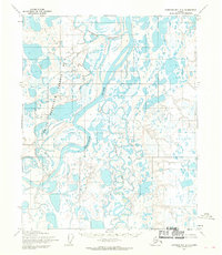
 2020 Harrison Bay A-2 NW2020 Print · USGSThe Arctic settlement of Nuiqsut is captured in the modern era as it sits along the Nechelik Channel. Researchers can trace the village street plan and local infrastructure, from the Nuiqsut Airport to the confluence of the Colville River and Itkillik River.
End of results
Showing maps 1-5 of 5
Frequently asked questions
- What are the different types of historical maps available for Nuiqsut?
- What is the oldest map of Nuiqsut?
- Where can I purchase historical maps of Nuiqsut for my home or office?
- Where can I download high-res historical maps of Nuiqsut?
- Are there historical topographic maps available for Nuiqsut?
- Is there historical aerial imagery available for Nuiqsut?
- Where are historical maps of Nuiqsut sourced from?