Old Maps of Annette, Alaska for Academic Research
Study the evolution of Annette with these high-resolution historic maps. Whether you're teaching, researching, or modeling changes in land use, these maps provide essential visual documentation of urban, environmental, and geographic change.
- Analyze long-term change: Track patterns in development, transportation, and natural features.
- Ideal for environmental or urban studies: Support academic projects with primary historical map data.
- Use in the classroom or lab: Educators and researchers rely on these maps to bring historical context to life.
These maps are a powerful tool for teaching, research, and visualizing how Annette has changed over the decades.
Annette, AK maps
- 1952 Map of Ketchikan, 1953 Print
 1952 Ketchikan1953 Print · USGSThe Ketchikan region of Southeast Alaska is mapped here in the early fifties, documenting the remote settlements and deep-water inlets of the southern panhandle. Genealogists and historians can trace the foundations of Ketchikan, Metlakatla, and Saxman alongside lonely backcountry cabins.4 unique versions available
 - 1955 Map of Ketchikan A-5, 1959 Print
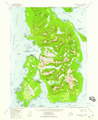 1955 Ketchikan A-51959 Print · USGSAnnette Island in the mid-fifties was a vital hub for both the local fishing industry and regional aviation. You can trace the infrastructure of Metlakatla, from the Metlakatla Cannery to the runways and Pass Terminal of the Annette Island Airport.3 unique versions available
 - 1955 Map of Ketchikan, 1966 Print
 1955 Ketchikan1966 Print · USGSSoutheast Alaska’s maritime character is captured in the mid-fifties, showing the vital waterways and remote outposts of the Alexander Archipelago. Researchers can trace the waterfronts of Ketchikan and Metlakatla or locate isolated spots like Hyder and Loring.3 unique versions available
 - 2017 Map of Ketchikan A-5 SW, 2017 Print
 2017 Ketchikan A-5 SW2017 Print · USGSCovers Annette, including Unorganized Borough, Prince of Wales-Hyder, and other nearby areas
 - 2021 Map of Ketchikan A-5 SW, 2021 Print
 2021 Ketchikan A-5 SW2021 Print · USGSAnnette Island is shown in its contemporary role as a hub for the Tsimshian community at the start of the 2020s. Researchers can trace the local infrastructure and landmarks such as the Metlakatla Cem, Annette Island Airport, and Tamgas Harbor.
End of results
Showing maps 1-5
Frequently asked questions
- What are the different types of historical maps available for Annette?
- What is the oldest map of Annette?
- Where can I purchase historical maps of Annette for my home or office?
- Where can I download high-res historical maps of Annette?
- Are there historical topographic maps available for Annette?
- Is there historical aerial imagery available for Annette?
- Where are historical maps of Annette sourced from?