Old Maps of Cape Pole, Alaska for Academic Research
Study the evolution of Cape Pole with 4 high-resolution historic maps. Whether you're teaching, researching, or modeling changes in land use, these maps provide essential visual documentation of urban, environmental, and geographic change.
- Analyze long-term change: Track patterns in development, transportation, and natural features.
- Ideal for environmental or urban studies: Support academic projects with primary historical map data.
- Use in the classroom or lab: Educators and researchers rely on these maps to bring historical context to life.
These maps are a powerful tool for teaching, research, and visualizing how Cape Pole has changed over the decades.
Cape Pole, AK maps
(4)- 1951 Map of Craig D-6, 1952 Print
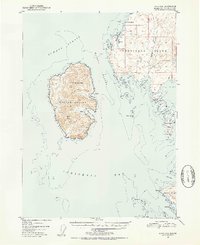 1951 Craig D-61952 Print · USGSCoastal Prince of Wales Island comes alive in the early fifties, showing the maritime isolation of the Alexander Archipelago. Trace the locations of early outposts at Cape Pole and remote Cabin sites near Halibut Harbor and Warren Cove.4 unique versions available
 - 1957 Map of Craig, 1959 Print
 1957 Craig1959 Print · USGSSoutheast Alaska’s intricate archipelago is revealed in the mid-1950s, detailing a coastal economy driven by remote mines and fishing outposts. Genealogists and historians can trace family roots in Craig, Hydaburg, and Klawak, or locate former sites like Tuxekan and the Salt Chuck Mine.3 unique versions available
 - 2017 Map of Craig D-6 NE, 2017 Print
 2017 Craig D-6 NE2017 Print · USGSCovers Cape Pole, including Unorganized Borough, Prince of Wales-Hyder, and other nearby areas
 - 2021 Map of Craig D-6 NE, 2021 Print
 2021 Craig D-6 NE2021 Print · USGSKosciusko Island in the early twenty-first century reveals a landscape of isolated settlements and winding forest roads within the Tongass National Forest. Researchers can trace the maritime access points at Cape Pole and Edna Bay or explore the detailed coastal geography of Shermans Harbor and Three Rock Cove.
End of results
Showing maps 1-4 of 4
Frequently asked questions
- What are the different types of historical maps available for Cape Pole?
- What is the oldest map of Cape Pole?
- Where can I purchase historical maps of Cape Pole for my home or office?
- Where can I download high-res historical maps of Cape Pole?
- Are there historical topographic maps available for Cape Pole?
- Is there historical aerial imagery available for Cape Pole?
- Where are historical maps of Cape Pole sourced from?