Old Maps of Hadley, Alaska for Genealogy
Trace your family roots with 5 historic maps of Hadley. These high-res maps reveal old neighborhoods, homesites, landmarks, and streets — helping you uncover where your ancestors lived and how the area evolved over time.
- Explore historic neighborhoods: Identify where your relatives may have lived in the 1800s or 1900s.
- Compare maps over time: Trace the changes in streets, buildings, and landmarks for multi-generational research.
- Perfect for genealogy & ancestry research: Used by family historians and researchers to map out lineage and migration.
These maps are an incredible resource for exploring your personal connection to Hadley's past.
Hadley, AK maps
(5)- 1950 Map of Craig C-1, 1966 Print
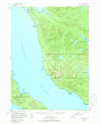 1950 Craig C-11966 Print · USGSThe rugged coastlines of the Cleveland Peninsula and Prince of Wales Island are captured here in the mid-century era. Historians can trace the legacy of local mining at Sleeping Beauty Mine and locate the site of the former settlement at Hadley.4 unique versions available
 - 1951 Map of Craig C-1, 1953 Print
 1951 Craig C-11953 Print · USGSThe Cleveland Peninsula and Prince of Wales Island are shown in the early fifties, documenting a landscape of maritime outposts and dormant mining camps. Genealogists and researchers can trace the abandoned site of Hadley and several inactive operations like the Mamie Mine or Sleeping Beauty Mine.2 unique versions available
 - 1957 Map of Craig, 1959 Print
 1957 Craig1959 Print · USGSSoutheast Alaska’s intricate archipelago is revealed in the mid-1950s, detailing a coastal economy driven by remote mines and fishing outposts. Genealogists and historians can trace family roots in Craig, Hydaburg, and Klawak, or locate former sites like Tuxekan and the Salt Chuck Mine.3 unique versions available
 - 2017 Map of Craig C-1 SW, 2017 Print
 2017 Craig C-1 SW2017 Print · USGSCovers Hadley, including Unorganized Borough, Prince of Wales-Hyder, and other nearby areas
 - 2021 Map of Craig C-1 SW, 2021 Print
 2021 Craig C-1 SW2021 Print · USGSThe maritime wilderness of Prince of Wales Island is captured here in the early twenty-first century, showing the dense forest and complex shoreline of the Alexander Archipelago. Maritime historians and researchers can locate landmarks like Lyman Anchorage, Sawmill Point, and the heights of Mt Andrew.
End of results
Showing maps 1-5 of 5
Top cities near Hadley
Frequently asked questions
- What are the different types of historical maps available for Hadley?
- What is the oldest map of Hadley?
- Where can I purchase historical maps of Hadley for my home or office?
- Where can I download high-res historical maps of Hadley?
- Are there historical topographic maps available for Hadley?
- Is there historical aerial imagery available for Hadley?
- Where are historical maps of Hadley sourced from?