Old Maps of Hydaburg, Alaska for Academic Research
Study the evolution of Hydaburg with 6 high-resolution historic maps. Whether you're teaching, researching, or modeling changes in land use, these maps provide essential visual documentation of urban, environmental, and geographic change.
- Analyze long-term change: Track patterns in development, transportation, and natural features.
- Ideal for environmental or urban studies: Support academic projects with primary historical map data.
- Use in the classroom or lab: Educators and researchers rely on these maps to bring historical context to life.
These maps are a powerful tool for teaching, research, and visualizing how Hydaburg has changed over the decades.
Hydaburg, AK maps
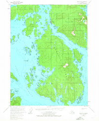
(6)- 1948 Map of Craig A-3, 1958 Print
 1948 Craig A-31958 Print · USGSCoastal Prince of Wales Island in the late 1940s is defined by its deep straits and the Haida community at Hydaburg. Trace the maritime routes through Sukkwan Strait or locate landmarks like Kasook Inlet and the McFarland Islands.
 - 1951 Map of Craig A-3, 1967 Print
 1951 Craig A-31967 Print · USGSThe coastal community of Hydaburg and the surrounding islands of the Alexander Archipelago are captured here in the early fifties. Local historians can trace maritime life through labels like the Aqueduct, Cem, and the narrow passages of Sukkwan Strait.3 unique versions available
 - 1957 Map of Craig, 1959 Print
 1957 Craig1959 Print · USGSSoutheast Alaska’s intricate archipelago is revealed in the mid-1950s, detailing a coastal economy driven by remote mines and fishing outposts. Genealogists and historians can trace family roots in Craig, Hydaburg, and Klawak, or locate former sites like Tuxekan and the Salt Chuck Mine.3 unique versions available
 - 1997 Map of Craig A-3, 2000 Print
 1997 Craig A-32000 Print · USGSPrince of Wales Island and the village of Hydaburg are shown in the late nineties as the coastal timber and fishing economy continued to shape the region. Genealogists and researchers can locate the Cem, trace the Hydaburg River, and explore the Lighthouse Reserve.
 - 2017 Map of Craig A-3 NE, 2017 Print
 2017 Craig A-3 NE2017 Print · USGSCovers Hydaburg, including Unorganized Borough, Prince of Wales-Hyder, and other nearby areas
 - 2021 Map of Craig A-3 NE, 2021 Print
 2021 Craig A-3 NE2021 Print · USGSHydaburg serves as the central hub of this coastal survey of Prince of Wales Island in the early 2020s. Genealogists and local historians can trace the streets of Hydaburg and locate landmarks like Saltery Point and Eek Lake.
End of results
Showing maps 1-6 of 6
Frequently asked questions
- What are the different types of historical maps available for Hydaburg?
- What is the oldest map of Hydaburg?
- Where can I purchase historical maps of Hydaburg for my home or office?
- Where can I download high-res historical maps of Hydaburg?
- Are there historical topographic maps available for Hydaburg?
- Is there historical aerial imagery available for Hydaburg?
- Where are historical maps of Hydaburg sourced from?