Old Maps of Polk Inlet, Alaska
Explore 6 old maps of Polk Inlet, spanning from 1949 to today. These high-resolution historic maps reveal how streets, neighborhoods, landmarks, and natural features evolved over time — perfect for genealogy, metal detecting, research, and local history exploration.
What you can do with these maps:
- See how Polk Inlet changed over time: Compare historical maps to modern-day views to trace roads, homesites, rail lines & more.
- View detailed metadata: Each map includes creators, publishers, year, scale, and archive source.
- Overlay maps with satellite & LiDAR: Visualize the past alongside modern tools to explore terrain & human change.
- Trusted historical sources: Maps sourced from the USGS, Library of Congress, and other archives.
- Access maps your way: View online, download high-res files, or order prints for personal or research use.
Start exploring old maps of Polk Inlet to uncover forgotten places, hidden landmarks, and the deep history beneath your feet.
Polk Inlet, AK maps
(6)- 1949 Map of Craig B-2, 1964 Print
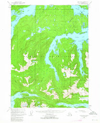 1949 Craig B-21964 Print · USGSThe intricate fjords of Prince of Wales Island are shown here just as post-war aviation and maritime traffic began to transform the archipelago. Researchers can trace the early industrial footprint of the Khayyam Mine and the historic Sulzer Portage near the settlement of Hollis.3 unique versions available
 - 1951 Map of Craig B-2, 1952 Print
 1951 Craig B-21952 Print · USGSSoutheast Alaska in the early fifties was a landscape of maritime industry and wilderness. Trace the remnants of coastal mining and heritage at Old Kasaan Nat Mon, the Khayam Mine (Inactive), and the site of Sulzer (Aban'd).2 unique versions available
 - 1957 Map of Craig, 1959 Print
 1957 Craig1959 Print · USGSSoutheast Alaska’s intricate archipelago is revealed in the mid-1950s, detailing a coastal economy driven by remote mines and fishing outposts. Genealogists and historians can trace family roots in Craig, Hydaburg, and Klawak, or locate former sites like Tuxekan and the Salt Chuck Mine.3 unique versions available
 - 1997 Map of Craig B-2, 2000 Print
 1997 Craig B-22000 Print · USGSPrince of Wales Island in the late nineties shows a landscape of deep fjords and industrial timber operations within the Tongass National Forest. Trace historical resource sites like the Khayyam Mine or the remote Logging Camp and Hollis settlements.
 - 2017 Map of Craig B-2 SW, 2017 Print
 2017 Craig B-2 SW2017 Print · USGSCovers Polk Inlet, including Unorganized Borough, Prince of Wales-Hyder, and other nearby areas
 - 2021 Map of Craig B-2 SW, 2021 Print
 2021 Craig B-2 SW2021 Print · USGSCoastal Prince of Wales Island comes alive in this recent survey of the Tongass National Forest. Local historians can trace resource management routes like Summit Spur and find remote landmarks such as Polk Inlet, Mt Jumbo, and Lake Isabel.
End of results
Showing maps 1-6 of 6
Top cities near Polk Inlet
Frequently asked questions
- What are the different types of historical maps available for Polk Inlet?
- What is the oldest map of Polk Inlet?
- Where can I purchase historical maps of Polk Inlet for my home or office?
- Where can I download high-res historical maps of Polk Inlet?
- Are there historical topographic maps available for Polk Inlet?
- Is there historical aerial imagery available for Polk Inlet?
- Where are historical maps of Polk Inlet sourced from?