Old Maps of Dry Creek, Alaska
Explore 6 old maps of Dry Creek, spanning from 1950 to today. These high-resolution historic maps reveal how streets, neighborhoods, landmarks, and natural features evolved over time — perfect for genealogy, metal detecting, research, and local history exploration.
What you can do with these maps:
- See how Dry Creek changed over time: Compare historical maps to modern-day views to trace roads, homesites, rail lines & more.
- View detailed metadata: Each map includes creators, publishers, year, scale, and archive source.
- Overlay maps with satellite & LiDAR: Visualize the past alongside modern tools to explore terrain & human change.
- Trusted historical sources: Maps sourced from the USGS, Library of Congress, and other archives.
- Access maps your way: View online, download high-res files, or order prints for personal or research use.
Start exploring old maps of Dry Creek to uncover forgotten places, hidden landmarks, and the deep history beneath your feet.
Dry Creek, AK maps
(6)- 1950 Map of Mount Hayes, 1955 Print
 1950 Mount Hayes1955 Print · USGSThe Alaska Interior in the early fifties shows a landscape of high peaks and essential roadhouse stops along the primitive highway system. Genealogists and historians can trace old travel routes and outposts like Rapids Roadhouse, Donnelly, and Paxson.2 unique versions available
 - 1951 Map of Mount Hayes
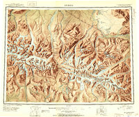 1951 Mount Hayes1951 Print · USGSIn the Alaska Range during the early fifties, the interior road network relied on isolated outposts and high-mountain passes. Researchers can trace the path of the Richardson Highway through Isabel Pass and find historic stops like Rapids Roadhouse and Millers Roadhouse.2 unique versions available
 - 1955 Map of Mount Hayes C-2, 1958 Print
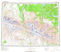
 1955 Mount Hayes C-21958 Print · USGSInterior Alaska in the mid-fifties is captured here along the critical Alaska Highway corridor during a period of infrastructure expansion. Researchers can trace the early path of the aboveground pipeline and the logistical Bureau of Public Roads Camp set against the Macomb Plateau.4 unique versions available
 - 1955 Map of Mount Hayes, 1966 Print
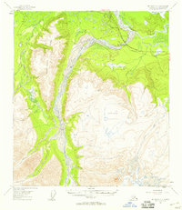
 1955 Mount Hayes1966 Print · USGSSoutheast Fairbanks and the Alaska Range are captured in the mid-1950s during the expansion of the interior highway system. Researchers can trace early settlements and military outposts like Donnelly, Black Rapids, and the expansive grounds of Fort Greely.4 unique versions available
 - 2016 Map of Mount Hayes C-2 NE, 2016 Print
 2016 Mount Hayes C-2 NE2016 Print · USGSCovers Dry Creek, including Unorganized Borough, United States, and other nearby areas
 - 2024 Map of Mount Hayes C-2 NE, 2024 Print
 2024 Mount Hayes C-2 NE2024 Print · USGSSoutheast Fairbanks is documented here as the modern corridor of the Alaska Highway meets the wild waters of the interior. Researchers can trace the winding course of the Tanana River and locate family landmarks near Horn Mtn or Moosehead Lake.
End of results
Showing maps 1-6 of 6
Frequently asked questions
- What are the different types of historical maps available for Dry Creek?
- What is the oldest map of Dry Creek?
- Where can I purchase historical maps of Dry Creek for my home or office?
- Where can I download high-res historical maps of Dry Creek?
- Are there historical topographic maps available for Dry Creek?
- Is there historical aerial imagery available for Dry Creek?
- Where are historical maps of Dry Creek sourced from?