1980s Maps of North Rim, Arizona
Explore 2 historic maps of North Rim from the 1980s. These maps offer a rare glimpse into what life looked like during the 1980s — showing old roads, neighborhoods, homes, and landmarks that have changed or disappeared over time.
Whether you're researching your family's past, planning a metal detecting trip, or studying how North Rim's landscape evolved across the 1980s, these high-resolution maps are a powerful tool for exploring the history of this region.
- Focus on a specific era: All maps on this page are from the 1980s, giving you a focused view of this time period.
- See what’s changed: Compare century-old streets, trails, and buildings to today's modern landscape using overlays and satellite layers.
- Research with precision: Use these maps for genealogy, historical research, land use analysis, or educational projects.
- View, download, or print: Maps are fully viewable online in high resolution, and can be downloaded or printed for your own records.
Start exploring North Rim's history through authentic maps from the 1980s. This is your window into the past.
North Rim, AZ maps
(2)- 1984 Map of Grand Canyon
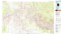 1984 Grand Canyon1984 Print · USGSThe Grand Canyon and surrounding plateaus are mapped here in the mid-1980s, detailing a complex landscape of tribal lands and national park boundaries. Trace historic routes like the Bright Angel Trail or locate remote sites such as Supai and the Orphan Mine.2 unique versions available
 - 1988 Map of Bright Angel Point
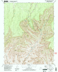 1988 Bright Angel Point1988 Print · USGSThe Grand Canyon's northern edge and interior canyons were meticulously documented in the late eighties, showing the transition from high plateau to river valley. Researchers can trace historic backcountry routes to Cottonwood Camp and landmarks like Buddha Temple or Ribbon Falls.2 unique versions available
End of results
Showing maps 1-2 of 2
Top cities near North Rim
Frequently asked questions
- What are the different types of historical maps available for North Rim?
- What is the oldest map of North Rim?
- Where can I purchase historical maps of North Rim for my home or office?
- Where can I download high-res historical maps of North Rim?
- Are there historical topographic maps available for North Rim?
- Is there historical aerial imagery available for North Rim?
- Where are historical maps of North Rim sourced from?