Old Maps of Point of Pines, Arizona for Genealogy
Trace your family roots with 10 historic maps of Point of Pines. These high-res maps reveal old neighborhoods, homesites, landmarks, and streets — helping you uncover where your ancestors lived and how the area evolved over time.
- Explore historic neighborhoods: Identify where your relatives may have lived in the 1800s or 1900s.
- Compare maps over time: Trace the changes in streets, buildings, and landmarks for multi-generational research.
- Perfect for genealogy & ancestry research: Used by family historians and researchers to map out lineage and migration.
These maps are an incredible resource for exploring your personal connection to Point of Pines's past.
Point of Pines, AZ maps
(10)- 1954 Map of Clifton, 1968 Print
 1954 Clifton1968 Print · USGSThe high timber and copper country of the Arizona-New Mexico border is captured here during the mid-fifties. Genealogists and historians can trace family holdings like the Double Circle Ranch or study the industrial footprint of the Smelting Plant at Clifton.3 unique versions available
 - 1957 Map of Clifton
 1957 Clifton1957 Print · USGSThe copper-mining district around Clifton and Morenci meets the high timberlands of the Mogollon Rim during the mid-1950s. Genealogists and researchers can trace family-named outposts and remote mountain settlements like Reserve, Stargo, and Fort Thomas.
 - 1958 Map of Clifton
 1958 Clifton1958 Print · USGSThe rugged high country of the Arizona-New Mexico border comes into focus in the mid-fifties, showing a landscape of mining camps and forest outposts. Genealogists and researchers can trace old settlements and remote sites like Mogollon, East Fork Mission, and the Tidwell Mine.
 - 1962 Map of Clifton
 1962 Clifton1962 Print · USGSThe copper-rich Arizona-New Mexico borderlands come into focus in the early sixties, centered on the mining complexes of Morenci and Clifton. Researchers can trace the Southern Pacific rail lines and locate remote outposts like Honeymoon and the Double Circle Ranch.
 - 1967 Map of Point of Pines West, 1971 Print
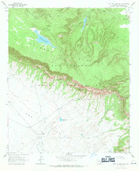 1967 Point of Pines West1971 Print · USGSThe San Carlos Indian Reservation in the late sixties reveals a landscape of dramatic elevation shifts across the Nan Tac Rim. Researchers can find evidence of ancient and modern habitation, from a Cliff Dwelling to the Lookout Tower and the settlement at Point of Pines.2 unique versions available
 - 1986 Map of Clifton, 1987 Print
 1986 Clifton1987 Print · USGSArizona's copper country and the rugged borderlands come into sharp focus in the mid-1980s. Researchers can trace the massive Morenci Open Pit and its rail connections to Clifton, alongside remote outposts like Point of Pines and Fort Thomas.2 unique versions available
 - 2011 Map of Point of Pines West, 2011 Print
 2011 Point of Pines West2011 Print · USGSCovers Point of Pines, including Graham County, United States, and other nearby areas
 - 2014 Map of Point of Pines West, 2014 Print
 2014 Point of Pines West2014 Print · USGSCovers Point of Pines, including Graham County, United States, and other nearby areas
 - 2018 Map of Point of Pines West, 2018 Print
 2018 Point of Pines West2018 Print · USGSCovers Point of Pines, including Graham County, United States, and other nearby areas
 - 2021 Map of Point of Pines West, 2021 Print
 2021 Point of Pines West2021 Print · USGSGraham County, Arizona, is shown here in the 2020s, highlighting the cattle-ranching landscape around the Nantac Rim. Researchers can trace the high-country routes through Barlow Pass and locate landmarks like Point of Pines and the Headquarters Tank.
End of results
Showing maps 1-10 of 10
Frequently asked questions
- What are the different types of historical maps available for Point of Pines?
- What is the oldest map of Point of Pines?
- Where can I purchase historical maps of Point of Pines for my home or office?
- Where can I download high-res historical maps of Point of Pines?
- Are there historical topographic maps available for Point of Pines?
- Is there historical aerial imagery available for Point of Pines?
- Where are historical maps of Point of Pines sourced from?