1980s Maps of Tartron, Arizona
Explore 3 historic maps of Tartron from the 1980s. These maps offer a rare glimpse into what life looked like during the 1980s — showing old roads, neighborhoods, homes, and landmarks that have changed or disappeared over time.
Whether you're researching your family's past, planning a metal detecting trip, or studying how Tartron's landscape evolved across the 1980s, these high-resolution maps are a powerful tool for exploring the history of this region.
- Focus on a specific era: All maps on this page are from the 1980s, giving you a focused view of this time period.
- See what’s changed: Compare century-old streets, trails, and buildings to today's modern landscape using overlays and satellite layers.
- Research with precision: Use these maps for genealogy, historical research, land use analysis, or educational projects.
- View, download, or print: Maps are fully viewable online in high resolution, and can be downloaded or printed for your own records.
Start exploring Tartron's history through authentic maps from the 1980s. This is your window into the past.
Tartron, AZ maps
(3)- 1980 Map of Dateland, 1996 Print
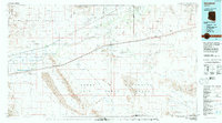 1980 Dateland1996 Print · USGSThe Yuma County desert during the late twentieth century is defined by the vital transit corridor along the Gila River. Researchers can trace the Southern Pacific rail line through remote stops like Sentinel and Aztec or locate the Sheep Mine in the rugged backcountry.
 - 1982 Map of Ajo
 1982 Ajo1982 Print · USGSThe Arizona-Sonora borderlands come into focus in the early eighties, showcasing a landscape of desert mining towns and expansive tribal lands. Trace the Southern Pacific rail line through Gila Bend or explore the remote settlements of Ajo and Lukeville.
 - 1986 Map of Sentinel NE
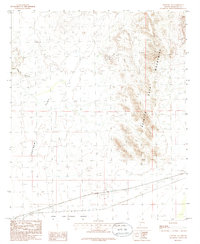 1986 Sentinel NE1986 Print · USGSMaricopa County's arid frontier is captured in the 1980s as a landscape defined by desert ranges and vital rail infrastructure. Trace the Southern Pacific line through Quito or locate old mining sites like the Mine Shaft in Wild Horse Canyon.
End of results
Showing maps 1-3 of 3
Top cities near Tartron
Frequently asked questions
- What are the different types of historical maps available for Tartron?
- What is the oldest map of Tartron?
- Where can I purchase historical maps of Tartron for my home or office?
- Where can I download high-res historical maps of Tartron?
- Are there historical topographic maps available for Tartron?
- Is there historical aerial imagery available for Tartron?
- Where are historical maps of Tartron sourced from?