1990s Maps of Hayhook Ranch, Arizona
Explore 3 historic maps of Hayhook Ranch from the 1990s. These maps offer a rare glimpse into what life looked like during the 1990s — showing old roads, neighborhoods, homes, and landmarks that have changed or disappeared over time.
Whether you're researching your family's past, planning a metal detecting trip, or studying how Hayhook Ranch's landscape evolved across the 1990s, these high-resolution maps are a powerful tool for exploring the history of this region.
- Focus on a specific era: All maps on this page are from the 1990s, giving you a focused view of this time period.
- See what’s changed: Compare century-old streets, trails, and buildings to today's modern landscape using overlays and satellite layers.
- Research with precision: Use these maps for genealogy, historical research, land use analysis, or educational projects.
- View, download, or print: Maps are fully viewable online in high resolution, and can be downloaded or printed for your own records.
Start exploring Hayhook Ranch's history through authentic maps from the 1990s. This is your window into the past.
Hayhook Ranch, AZ maps
(3)- 1992 Map of San Pedro, 1995 Print
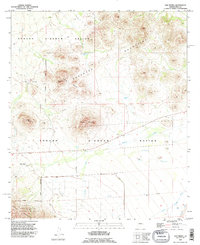 1992 San Pedro1995 Print · USGSThe Tohono O'odham Nation in Pima County is captured here in the early nineties, showing a landscape defined by mountain ranges and desert wells. Researchers can trace the area around San Pedro and Nawt Vaya, locating local landmarks like the Cem and Martina Mountain.
 - 1994 Map of Silver Bell Mountains
 1994 Silver Bell Mountains1994 Print · USGSSouthern Arizona in the mid-nineties shows a land of transition between desert wilderness, tribal lands, and the growing Tucson suburbs. Genealogists and historians can trace settlements like San Luis and Ko Vaya, or follow the industrial legacy of the Silver Bell Mine.2 unique versions available
 - 1996 Map of San Pedro, 2002 Print
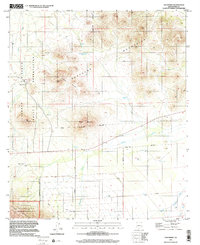 1996 San Pedro2002 Print · USGSThe Tohono O'odham Indian Reservation is captured in the late twentieth century as its traditional ranching landscape and mountain peaks remain largely untouched. Genealogists and historians can locate the San Pedro settlement, its Cem, and vital desert water sources like Townsend Well.
End of results
Showing maps 1-3 of 3
Frequently asked questions
- What are the different types of historical maps available for Hayhook Ranch?
- What is the oldest map of Hayhook Ranch?
- Where can I purchase historical maps of Hayhook Ranch for my home or office?
- Where can I download high-res historical maps of Hayhook Ranch?
- Are there historical topographic maps available for Hayhook Ranch?
- Is there historical aerial imagery available for Hayhook Ranch?
- Where are historical maps of Hayhook Ranch sourced from?