1980s Maps of Oro Valley, Arizona
Explore 2 historic maps of Oro Valley from the 1980s. These maps offer a rare glimpse into what life looked like during the 1980s — showing old roads, neighborhoods, homes, and landmarks that have changed or disappeared over time.
Whether you're researching your family's past, planning a metal detecting trip, or studying how Oro Valley's landscape evolved across the 1980s, these high-resolution maps are a powerful tool for exploring the history of this region.
- Focus on a specific era: All maps on this page are from the 1980s, giving you a focused view of this time period.
- See what’s changed: Compare century-old streets, trails, and buildings to today's modern landscape using overlays and satellite layers.
- Research with precision: Use these maps for genealogy, historical research, land use analysis, or educational projects.
- View, download, or print: Maps are fully viewable online in high resolution, and can be downloaded or printed for your own records.
Start exploring Oro Valley's history through authentic maps from the 1980s. This is your window into the past.
Oro Valley, AZ maps
(2)- 1981 Map of Oro Valley, 1982 Print
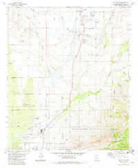 1981 Oro Valley1982 Print · USGSOro Valley and Catalina are shown during a period of rapid suburban growth in the early eighties. Researchers can trace the transition from rural ranching at Steam Pump Ranch to modern landmarks like Dennis Weaver Park and Canyon del Oro High Sch.3 unique versions available
 - 1984 Map of Tucson North
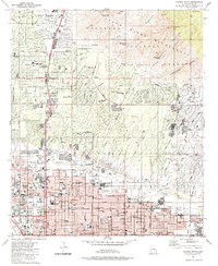 1984 Tucson North1984 Print · USGSNorth Tucson and the Catalina foothills come into focus in the mid-1980s as suburban development meets the wilderness. Researchers can trace established landmarks like Evergreen Cemetery, the Rillito Downs Race Track, and the growing neighborhoods of Casas Adobes.
End of results
Showing maps 1-2 of 2
Top cities near Oro Valley
- Tucson historical maps
- Marana historical maps
- Saddlebrooke historical maps
- Catalina historical maps
- South Tucson historical maps
- Oracle historical maps
See more
Frequently asked questions
- What are the different types of historical maps available for Oro Valley?
- What is the oldest map of Oro Valley?
- Where can I purchase historical maps of Oro Valley for my home or office?
- Where can I download high-res historical maps of Oro Valley?
- Are there historical topographic maps available for Oro Valley?
- Is there historical aerial imagery available for Oro Valley?
- Where are historical maps of Oro Valley sourced from?