1990s Maps of Viason Chin, Pisinemo District
Explore 2 historic maps of Viason Chin from the 1990s. These maps offer a rare glimpse into what life looked like during the 1990s — showing old roads, neighborhoods, homes, and landmarks that have changed or disappeared over time.
Whether you're researching your family's past, planning a metal detecting trip, or studying how Viason Chin's landscape evolved across the 1990s, these high-resolution maps are a powerful tool for exploring the history of this region.
- Focus on a specific era: All maps on this page are from the 1990s, giving you a focused view of this time period.
- See what’s changed: Compare century-old streets, trails, and buildings to today's modern landscape using overlays and satellite layers.
- Research with precision: Use these maps for genealogy, historical research, land use analysis, or educational projects.
- View, download, or print: Maps are fully viewable online in high resolution, and can be downloaded or printed for your own records.
Start exploring Viason Chin's history through authentic maps from the 1990s. This is your window into the past.
Viason Chin, Pisinemo District maps
- 1990 Map of Pisinimo
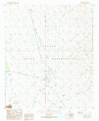 1990 Pisinimo1990 Print · USGSThe Papago Indian Reservation in the 1990s reveals a desert landscape defined by traditional settlements and clever water management. Researchers can trace the layout of Pisinimo, locate the Cem, and find historical locations such as Viason Chin (Site) and Peach Pu.
 - 1996 Map of Pisinimo, 2001 Print
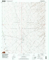 1996 Pisinimo2001 Print · USGSThe Tohono O'odham nation in the mid-nineties is documented here across a landscape of desert washes and traditional sites. Genealogists and historians can trace local landmarks like Pisinimo, the San Antonio Well, and the historic Vlason Chin (Site).
End of results
Showing maps 1-2
Frequently asked questions
- What are the different types of historical maps available for Viason Chin?
- What is the oldest map of Viason Chin?
- Where can I purchase historical maps of Viason Chin for my home or office?
- Where can I download high-res historical maps of Viason Chin?
- Are there historical topographic maps available for Viason Chin?
- Is there historical aerial imagery available for Viason Chin?
- Where are historical maps of Viason Chin sourced from?