1940s Maps of San Xavier, Arizona
Explore 2 historic maps of San Xavier from the 1940s. These maps offer a rare glimpse into what life looked like during the 1940s — showing old roads, neighborhoods, homes, and landmarks that have changed or disappeared over time.
Whether you're researching your family's past, planning a metal detecting trip, or studying how San Xavier's landscape evolved across the 1940s, these high-resolution maps are a powerful tool for exploring the history of this region.
- Focus on a specific era: All maps on this page are from the 1940s, giving you a focused view of this time period.
- See what’s changed: Compare century-old streets, trails, and buildings to today's modern landscape using overlays and satellite layers.
- Research with precision: Use these maps for genealogy, historical research, land use analysis, or educational projects.
- View, download, or print: Maps are fully viewable online in high resolution, and can be downloaded or printed for your own records.
Start exploring San Xavier's history through authentic maps from the 1940s. This is your window into the past.
San Xavier, AZ maps
(2)- 1941 Map of Twin Buttes
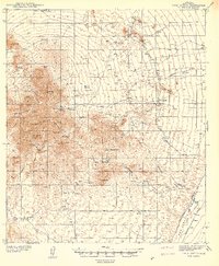 1941 Twin Buttes1941 Print · USGSSouthern Arizona ranching and mining culture is well-documented in this late-1930s survey of the Sierrita foothills. Researchers can locate the McGee Sch, the rails of the Southern Pacific RR, and family-named landmarks like Canoa Ranch and Harris Ranch.
 - 1948 Map of Twin Buttes
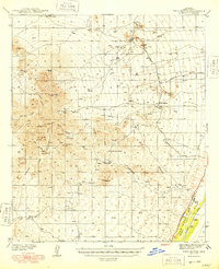 1948 Twin Buttes1948 Print · USGSPima County's ranching and mining heart is captured here in the late 1930s, showing the high desert before modern development. Trace family landholdings and rural hubs like Soto Ranch, McGee Sch, and the riverside rail stop at Canoa.2 unique versions available
End of results
Showing maps 1-2 of 2
Top cities near San Xavier
Frequently asked questions
- What are the different types of historical maps available for San Xavier?
- What is the oldest map of San Xavier?
- Where can I purchase historical maps of San Xavier for my home or office?
- Where can I download high-res historical maps of San Xavier?
- Are there historical topographic maps available for San Xavier?
- Is there historical aerial imagery available for San Xavier?
- Where are historical maps of San Xavier sourced from?