1990s Maps of Chiawuli Tak, Schuk Toak District
Explore 2 historic maps of Chiawuli Tak from the 1990s. These maps offer a rare glimpse into what life looked like during the 1990s — showing old roads, neighborhoods, homes, and landmarks that have changed or disappeared over time.
Whether you're researching your family's past, planning a metal detecting trip, or studying how Chiawuli Tak's landscape evolved across the 1990s, these high-resolution maps are a powerful tool for exploring the history of this region.
- Focus on a specific era: All maps on this page are from the 1990s, giving you a focused view of this time period.
- See what’s changed: Compare century-old streets, trails, and buildings to today's modern landscape using overlays and satellite layers.
- Research with precision: Use these maps for genealogy, historical research, land use analysis, or educational projects.
- View, download, or print: Maps are fully viewable online in high resolution, and can be downloaded or printed for your own records.
Start exploring Chiawuli Tak's history through authentic maps from the 1990s. This is your window into the past.
Chiawuli Tak, Schuk Toak District maps
(2)- 1994 Map of Sells
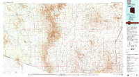 1994 Sells1994 Print · USGSSouthern Arizona in the mid-nineties shows a landscape of deep cultural history, from the Tohono O'odham Nation to the historic Santa Cruz River valley. Genealogists and historians can trace desert settlements like Pisinimo, explore the border town of Sasabe, and locate the mining operations at Mission Mine.2 unique versions available
 - 1996 Map of Sells East, 2002 Print
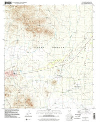 1996 Sells East2002 Print · USGSThe Tohono O'odham nation centers on Sells in the late twentieth century, showing a landscape of desert villages and vital water sources. Researchers can trace the layout of Sells, identify local landmarks like Ali Chukson, and locate the Our Lady of Lourdes Mission.
End of results
Showing maps 1-2 of 2
Top cities near Chiawuli Tak
Frequently asked questions
- What are the different types of historical maps available for Chiawuli Tak?
- What is the oldest map of Chiawuli Tak?
- Where can I purchase historical maps of Chiawuli Tak for my home or office?
- Where can I download high-res historical maps of Chiawuli Tak?
- Are there historical topographic maps available for Chiawuli Tak?
- Is there historical aerial imagery available for Chiawuli Tak?
- Where are historical maps of Chiawuli Tak sourced from?