1940s Maps of San Vicente, Schuk Toak District
Explore 3 historic maps of San Vicente from the 1940s. These maps offer a rare glimpse into what life looked like during the 1940s — showing old roads, neighborhoods, homes, and landmarks that have changed or disappeared over time.
Whether you're researching your family's past, planning a metal detecting trip, or studying how San Vicente's landscape evolved across the 1940s, these high-resolution maps are a powerful tool for exploring the history of this region.
- Focus on a specific era: All maps on this page are from the 1940s, giving you a focused view of this time period.
- See what’s changed: Compare century-old streets, trails, and buildings to today's modern landscape using overlays and satellite layers.
- Research with precision: Use these maps for genealogy, historical research, land use analysis, or educational projects.
- View, download, or print: Maps are fully viewable online in high resolution, and can be downloaded or printed for your own records.
Start exploring San Vicente's history through authentic maps from the 1940s. This is your window into the past.
San Vicente, Schuk Toak District maps
(3)- 1941 Map of San Vicente
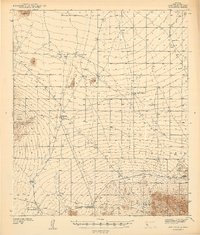 1941 San Vicente1941 Print · USGSPima County ranching and tribal lands are captured in the late 1930s before modern development altered this desert landscape. Genealogists and historians can trace family-named sites like San Ignacio Ranch and settlements including San Vicente and Haivana Nakya.
 - 1942 Map of San Vicente
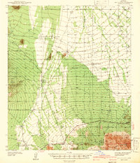 1942 San Vicente1942 Print · USGSThe Sonoran desert landscape of Pima County is captured here in the late 1930s, showing the early ranching and mining infrastructure of the Papago Indian Reservation. Genealogists and historians can locate remote outposts like San Ignacio Ranch, Wattle Hut, and the Roadside Mine.
 - 1948 Map of San Vicente
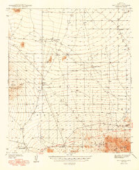 1948 San Vicente1948 Print · USGSWithin the Papago Indian Reservation in the late thirties, this survey shows a resilient desert landscape of cattle tanks and remote ranching outposts. Trace the locations of Havana Nakya, the Roadside Mine, and the Ajo-Tucson Highway as they appeared before mid-century growth.2 unique versions available
End of results
Showing maps 1-3 of 3
Top cities near San Vicente
Frequently asked questions
- What are the different types of historical maps available for San Vicente?
- What is the oldest map of San Vicente?
- Where can I purchase historical maps of San Vicente for my home or office?
- Where can I download high-res historical maps of San Vicente?
- Are there historical topographic maps available for San Vicente?
- Is there historical aerial imagery available for San Vicente?
- Where are historical maps of San Vicente sourced from?