1940s Maps of Barkerville, Arizona
Explore 2 historic maps of Barkerville from the 1940s. These maps offer a rare glimpse into what life looked like during the 1940s — showing old roads, neighborhoods, homes, and landmarks that have changed or disappeared over time.
Whether you're researching your family's past, planning a metal detecting trip, or studying how Barkerville's landscape evolved across the 1940s, these high-resolution maps are a powerful tool for exploring the history of this region.
- Focus on a specific era: All maps on this page are from the 1940s, giving you a focused view of this time period.
- See what’s changed: Compare century-old streets, trails, and buildings to today's modern landscape using overlays and satellite layers.
- Research with precision: Use these maps for genealogy, historical research, land use analysis, or educational projects.
- View, download, or print: Maps are fully viewable online in high resolution, and can be downloaded or printed for your own records.
Start exploring Barkerville's history through authentic maps from the 1940s. This is your window into the past.
Barkerville, AZ maps
(2)- 1949 Map of Winkelman, 1961 Print
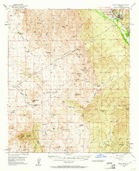 1949 Winkelman1961 Print · USGSThe copper-rich river valleys of Pinal County are captured here in the late 1940s, centered on the bustling junction of the Gila and San Pedro. Researchers can trace historic ranching and mining operations like Old Silver Queen Mine, Barkerville, and the Tony Lopez Ranch.3 unique versions available
 - 1949 Map of Black Mountain, 1961 Print
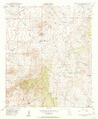 1949 Black Mountain1961 Print · USGSPinal County ranching and mining country is captured here during the late 1940s, showing a landscape defined by seasonal washes and high desert buttes. Genealogists and researchers can trace family-named outposts like Haydon Ranch and the historical Barkerville (Site).3 unique versions available
End of results
Showing maps 1-2 of 2
Top cities near Barkerville
Frequently asked questions
- What are the different types of historical maps available for Barkerville?
- What is the oldest map of Barkerville?
- Where can I purchase historical maps of Barkerville for my home or office?
- Where can I download high-res historical maps of Barkerville?
- Are there historical topographic maps available for Barkerville?
- Is there historical aerial imagery available for Barkerville?
- Where are historical maps of Barkerville sourced from?