1980s Maps of Oracle Junction, Arizona
Explore 2 historic maps of Oracle Junction from the 1980s. These maps offer a rare glimpse into what life looked like during the 1980s — showing old roads, neighborhoods, homes, and landmarks that have changed or disappeared over time.
Whether you're researching your family's past, planning a metal detecting trip, or studying how Oracle Junction's landscape evolved across the 1980s, these high-resolution maps are a powerful tool for exploring the history of this region.
- Focus on a specific era: All maps on this page are from the 1980s, giving you a focused view of this time period.
- See what’s changed: Compare century-old streets, trails, and buildings to today's modern landscape using overlays and satellite layers.
- Research with precision: Use these maps for genealogy, historical research, land use analysis, or educational projects.
- View, download, or print: Maps are fully viewable online in high resolution, and can be downloaded or printed for your own records.
Start exploring Oracle Junction's history through authentic maps from the 1980s. This is your window into the past.
Oracle Junction, AZ maps
(2)- 1986 Map of Mammoth, 1987 Print
 1986 Mammoth1987 Print · USGSThe copper-rich corridors of Pinal and Graham counties are captured in the mid-1980s as mining towns and mountain wilderness met. Researchers can trace the industrial footprints of the San Manuel Mine and Hayden, alongside landmarks like the Silver Queen Mine and Aravaipa Creek.3 unique versions available
 - 1988 Map of Oracle Junction, 1989 Print
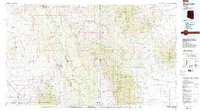
 1988 Oracle Junction1989 Print · USGSThe desert north of Tucson was transitioning into a suburban corridor in the late eighties, centered on the highway crossroads. Genealogists and historians can trace development patterns around Oracle Junction and Catalina, alongside rural landmarks like a mine shaft and Indian Town Reservoir.2 unique versions available
End of results
Showing maps 1-2 of 2
Top cities near Oracle Junction
- Marana historical maps
- Oro Valley historical maps
- Saddlebrooke historical maps
- Catalina historical maps
- Oracle historical maps
- Rillito historical maps
Frequently asked questions
- What are the different types of historical maps available for Oracle Junction?
- What is the oldest map of Oracle Junction?
- Where can I purchase historical maps of Oracle Junction for my home or office?
- Where can I download high-res historical maps of Oracle Junction?
- Are there historical topographic maps available for Oracle Junction?
- Is there historical aerial imagery available for Oracle Junction?
- Where are historical maps of Oracle Junction sourced from?