1940s Maps of Rancho San Manuel, Pinal County
Explore 5 historic maps of Rancho San Manuel from the 1940s. These maps offer a rare glimpse into what life looked like during the 1940s — showing old roads, neighborhoods, homes, and landmarks that have changed or disappeared over time.
Whether you're researching your family's past, planning a metal detecting trip, or studying how Rancho San Manuel's landscape evolved across the 1940s, these high-resolution maps are a powerful tool for exploring the history of this region.
- Focus on a specific era: All maps on this page are from the 1940s, giving you a focused view of this time period.
- See what’s changed: Compare century-old streets, trails, and buildings to today's modern landscape using overlays and satellite layers.
- Research with precision: Use these maps for genealogy, historical research, land use analysis, or educational projects.
- View, download, or print: Maps are fully viewable online in high resolution, and can be downloaded or printed for your own records.
Start exploring Rancho San Manuel's history through authentic maps from the 1940s. This is your window into the past.
Rancho San Manuel, Pinal County maps
(5)- 1948 Map of Mammoth, 1959 Print
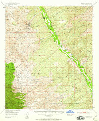 1948 Mammoth1959 Print · USGSThe San Pedro River valley and the surrounding Pinal County foothills appear in detail just as the local copper industry was modernizing. Researchers can trace the layout of mining hubs like Tiger and Mammoth, alongside historic spreads such as American Flag Ranch and 3 C Ranch.2 unique versions available
 - 1948 Map of Campo Bonito, 1961 Print
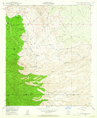 1948 Campo Bonito1961 Print · USGSThe eastern Catalina foothills were a busy junction of mining and ranching just after the war. Researchers can trace the layout of historic operations like the Southern Belle Mine and Old Maudina Mine, or locate early homesteads including Kannally Ranch and American Flag Ranch.5 unique versions available
 - 1948 Map of Peppersauce Wash, 1965 Print
 1948 Peppersauce Wash1965 Print · USGSThe San Pedro River valley and the rugged Black Hills of southern Arizona are captured here in the late 1940s. Genealogists and historians can trace desert water sources and early industry through sites like the Black Hills Mine, Sacaton Ranch, and a rare Artesian Well.3 unique versions available
 - 1949 Map of Campo Bonito
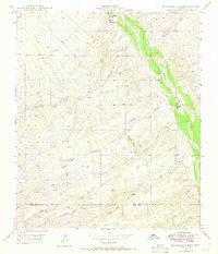
 1949 Campo Bonito1949 Print · USGSThe high Catalina foothills come alive in the late 1940s, showing a rugged landscape of ranching and hard-rock mining. You can locate family ranch boundaries like C O D Ranch and 3 C Ranch alongside historic workings such as the Old Maudina Mine and Southern Belle Mine.2 unique versions available
 - 1949 Map of Peppersauce Wash
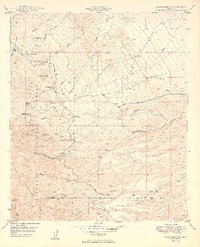
 1949 Peppersauce Wash1949 Print · USGSThe San Pedro River valley and the eastern slopes of the Black Hills appear here in the late 1940s, showing a land defined by desert ranching and mineral exploration. Researchers can trace the layout of the Sacaton Ranch, locate the Black Hills Mine, and follow water sources like the Artesian Well (Hot).
End of results
Showing maps 1-5 of 5
Frequently asked questions
- What are the different types of historical maps available for Rancho San Manuel?
- What is the oldest map of Rancho San Manuel?
- Where can I purchase historical maps of Rancho San Manuel for my home or office?
- Where can I download high-res historical maps of Rancho San Manuel?
- Are there historical topographic maps available for Rancho San Manuel?
- Is there historical aerial imagery available for Rancho San Manuel?
- Where are historical maps of Rancho San Manuel sourced from?