1990s Maps of Van Buren, Arkansas
Explore 2 historic maps of Van Buren from the 1990s. These maps offer a rare glimpse into what life looked like during the 1990s — showing old roads, neighborhoods, homes, and landmarks that have changed or disappeared over time.
Whether you're researching your family's past, planning a metal detecting trip, or studying how Van Buren's landscape evolved across the 1990s, these high-resolution maps are a powerful tool for exploring the history of this region.
- Focus on a specific era: All maps on this page are from the 1990s, giving you a focused view of this time period.
- See what’s changed: Compare century-old streets, trails, and buildings to today's modern landscape using overlays and satellite layers.
- Research with precision: Use these maps for genealogy, historical research, land use analysis, or educational projects.
- View, download, or print: Maps are fully viewable online in high resolution, and can be downloaded or printed for your own records.
Start exploring Van Buren's history through authentic maps from the 1990s. This is your window into the past.
Van Buren, AR maps
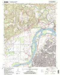
(2)- 1997 Map of Van Buren, 1999 Print
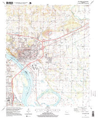 1997 Van Buren1999 Print · USGSVan Buren and the northern edge of Fort Smith appear here in the late nineties as a bustling river-and-rail corridor. Researchers can trace family history through sites like Antioch Cem or locate former community centers like Shibley and Wright Town.
 - 1997 Map of Fort Smith, 1999 Print
 1997 Fort Smith1999 Print · USGSFort Smith and the surrounding borderlands of Oklahoma and Arkansas are captured here during the late nineties, showing the city's expansion toward the river. Genealogists can trace family footprints at the National Cemetery or locate old neighborhood landmarks like Spradling School and Alexander Memorial Church.2 unique versions available
End of results
Showing maps 1-2 of 2
Top cities near Van Buren
- Fort Smith historical maps
- Greenwood historical maps
- Alma historical maps
- Barling historical maps
- Pocola historical maps
- Muldrow historical maps
See more
Top neighborhoods of Van Buren
Frequently asked questions
- What are the different types of historical maps available for Van Buren?
- What is the oldest map of Van Buren?
- Where can I purchase historical maps of Van Buren for my home or office?
- Where can I download high-res historical maps of Van Buren?
- Are there historical topographic maps available for Van Buren?
- Is there historical aerial imagery available for Van Buren?
- Where are historical maps of Van Buren sourced from?