1980s Maps of Oxford, Arkansas
Explore 4 historic maps of Oxford from the 1980s. These maps offer a rare glimpse into what life looked like during the 1980s — showing old roads, neighborhoods, homes, and landmarks that have changed or disappeared over time.
Whether you're researching your family's past, planning a metal detecting trip, or studying how Oxford's landscape evolved across the 1980s, these high-resolution maps are a powerful tool for exploring the history of this region.
- Focus on a specific era: All maps on this page are from the 1980s, giving you a focused view of this time period.
- See what’s changed: Compare century-old streets, trails, and buildings to today's modern landscape using overlays and satellite layers.
- Research with precision: Use these maps for genealogy, historical research, land use analysis, or educational projects.
- View, download, or print: Maps are fully viewable online in high resolution, and can be downloaded or printed for your own records.
Start exploring Oxford's history through authentic maps from the 1980s. This is your window into the past.
Oxford, AR maps
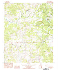
(4)- 1983 Map of Cherokee Village
 1983 Cherokee Village1983 Print · USGSThe Ozark foothills and river valleys of Northeast Arkansas are captured in the early eighties as modern planned communities began to reshape the landscape. Genealogists and historians can trace family-named ridges and schools across Evening Shade, Melbourne, and the rail junction at Hoxie.
 - 1984 Map of Byron
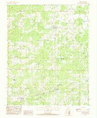
 1984 Byron1984 Print · USGSThe rural Arkansas borderlands of Fulton and Izard Counties are captured in the early eighties, showcasing a landscape of dispersed farmsteads and small crossroads. Genealogists can trace family footprints at Liberty Cem, Harmony Cem, and the quiet community of Byron.
 - 1984 Map of Franklin
 1984 Franklin1984 Print · USGSNorth Central Arkansas in the early eighties shows a landscape of river-valley settlements and growing recreational hubs. Genealogists and historians can trace family sites at Old Liberty Cem, locate the rural community of Violet Hill, or study the development of Horseshoe Bend.
 - 1984 Map of Oxford
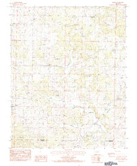
 1984 Oxford1984 Print · USGSOzark foothills in Izard County come into focus during the early eighties, showing a landscape of dispersed settlements and winding creeks. Genealogists can locate family burial sites at Blankenship Cem and Owens Cem or trace the rural roads connecting Oxford to Band Mill.
End of results
Showing maps 1-4 of 4
Top cities near Oxford
- Horseshoe Bend historical maps
- Melbourne historical maps
- Salem historical maps
- Calico Rock historical maps
- Mount Pleasant historical maps
- Viola historical maps
See more
Frequently asked questions
- What are the different types of historical maps available for Oxford?
- What is the oldest map of Oxford?
- Where can I purchase historical maps of Oxford for my home or office?
- Where can I download high-res historical maps of Oxford?
- Are there historical topographic maps available for Oxford?
- Is there historical aerial imagery available for Oxford?
- Where are historical maps of Oxford sourced from?