1970s Maps of Palmer, Arkansas
Explore 2 historic maps of Palmer from the 1970s. These maps offer a rare glimpse into what life looked like during the 1970s — showing old roads, neighborhoods, homes, and landmarks that have changed or disappeared over time.
Whether you're researching your family's past, planning a metal detecting trip, or studying how Palmer's landscape evolved across the 1970s, these high-resolution maps are a powerful tool for exploring the history of this region.
- Focus on a specific era: All maps on this page are from the 1970s, giving you a focused view of this time period.
- See what’s changed: Compare century-old streets, trails, and buildings to today's modern landscape using overlays and satellite layers.
- Research with precision: Use these maps for genealogy, historical research, land use analysis, or educational projects.
- View, download, or print: Maps are fully viewable online in high resolution, and can be downloaded or printed for your own records.
Start exploring Palmer's history through authentic maps from the 1970s. This is your window into the past.
Palmer, AR maps
(2)- 1971 Map of Pine City, 1973 Print
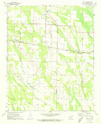 1971 Pine City1973 Print · USGSThe Arkansas Delta comes alive in the early seventies as the Missouri Pacific crosses the Monroe County line. Genealogists and historians can trace local life through small settlements like Ragtown, Postelle, and the rural St Marks Ch.
 - 1974 Map of Holly Grove
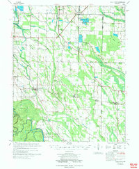 1974 Holly Grove1974 Print · USGSEastern Arkansas at the start of the 1970s reveals a landscape of specialized aquaculture and historic survey points. Genealogists and historians can trace numerous rural congregations and burial sites like Big Star Ch, Postelle Cem, and the Louisiana Purchase Monument.
End of results
Showing maps 1-2 of 2
Top cities near Palmer
- Marvell historical maps
- Holly Grove historical maps
- Saint Charles historical maps
- Moro historical maps
- Aubrey historical maps
Frequently asked questions
- What are the different types of historical maps available for Palmer?
- What is the oldest map of Palmer?
- Where can I purchase historical maps of Palmer for my home or office?
- Where can I download high-res historical maps of Palmer?
- Are there historical topographic maps available for Palmer?
- Is there historical aerial imagery available for Palmer?
- Where are historical maps of Palmer sourced from?