1900s (20th Century) Maps of Oden, Arkansas
Explore 8 historic maps of Oden from the 1900s (20th Century). These maps offer a rare glimpse into what life looked like during the 1900s — showing old roads, neighborhoods, homes, and landmarks that have changed or disappeared over time.
Whether you're researching your family's past, planning a metal detecting trip, or studying how Oden's landscape evolved across the 1900s, these high-resolution maps are a powerful tool for exploring the history of this region.
- Focus on a specific era: All maps on this page are from the 1900s, giving you a focused view of this time period.
- See what’s changed: Compare century-old streets, trails, and buildings to today's modern landscape using overlays and satellite layers.
- Research with precision: Use these maps for genealogy, historical research, land use analysis, or educational projects.
- View, download, or print: Maps are fully viewable online in high resolution, and can be downloaded or printed for your own records.
Start exploring Oden's history through authentic maps from the 1900s. This is your window into the past.
Oden, AR maps
(8)- 1955 Map of Little Rock, 1978 Print
 1955 Little Rock1978 Print · USGSCentral Arkansas in the mid-fifties exhibits a landscape of growing cities, massive military installations, and mountain reservoirs. Genealogists and historians can trace the industrial Bauxite Mines, regional rail lines, and local landmarks like Antioch Church.
 - 1956 Map of Little Rock
 1956 Little Rock1956 Print · USGSCentral Arkansas in the mid-fifties shows a landscape defined by burgeoning military bases and the timber-and-mineral wealth of the Ouachitas. Genealogists and researchers can trace old rail lines like the Missouri Pacific and find established communities such as Bauxite, Sheridan, and Mabelvale.
 - 1959 Map of Oden, 1960 Print
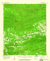 1959 Oden1960 Print · USGSThe Ouachita River valley in the late fifties is a landscape of mountain ridges and riverside settlements. Researchers can trace family history through local landmarks like Pine Ridge, the Goodner Cem, and the Gaston Lookout Tower.2 unique versions available
 - 1960 Map of Little Rock
 1960 Little Rock1960 Print · USGSCentral Arkansas in the late fifties shows a landscape of growing military bases and massive new reservoirs. Local historians can trace the mid-century expansion of Little Rock and Hot Springs alongside the industrial works at Bauxite and the Pine Bluff Arsenal.
 - 1964 Map of Little Rock
 1964 Little Rock1964 Print · USGSCentral Arkansas in the mid-sixties is a landscape of mountain ridges, industrial rail lines, and growing military hubs. Researchers can trace the development of Bauxite and Hot Springs or locate rural landmarks like Sparkman and the Pine Bluff Arsenal.
 - 1982 Map of Lake Ouachita
 1982 Lake Ouachita1982 Print · USGSThe Ouachita Mountains of West Central Arkansas are shown here during the early eighties, a time of established recreation and protected timberlands. Researchers can locate small communities like Buckville (PO) and Pencil Bluff or trace the drainage of the Fourche La Fave River.
 - 1985 Map of Brushy Creek Mountain, 1986 Print
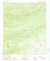 1985 Brushy Creek Mountain1986 Print · USGSMontgomery County was characterized by dense timber and isolated mountain settlements in the mid-eighties. Genealogists and hikers can trace the geography around Oden, find the Cem on Big Brushy Creek, or explore the heights of Mill Creek Mountain.
 - 1985 Map of Oden, 1986 Print
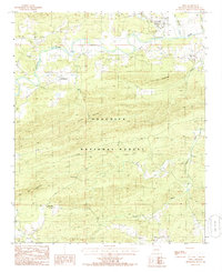 1985 Oden1986 Print · USGSIn the heart of the Ouachita Mountains during the mid-eighties, this survey captures the river-valley communities and timberlands of Montgomery County. Researchers can trace family roots in Oden, find the Union Hill Ch, or locate landmarks like Hog Jaw Mountain and Rock Spring.
End of results
Showing maps 1-8 of 8
Top cities near Oden
Frequently asked questions
- What are the different types of historical maps available for Oden?
- What is the oldest map of Oden?
- Where can I purchase historical maps of Oden for my home or office?
- Where can I download high-res historical maps of Oden?
- Are there historical topographic maps available for Oden?
- Is there historical aerial imagery available for Oden?
- Where are historical maps of Oden sourced from?