1940s Maps of Raspberry, Arkansas
Explore 2 historic maps of Raspberry from the 1940s. These maps offer a rare glimpse into what life looked like during the 1940s — showing old roads, neighborhoods, homes, and landmarks that have changed or disappeared over time.
Whether you're researching your family's past, planning a metal detecting trip, or studying how Raspberry's landscape evolved across the 1940s, these high-resolution maps are a powerful tool for exploring the history of this region.
- Focus on a specific era: All maps on this page are from the 1940s, giving you a focused view of this time period.
- See what’s changed: Compare century-old streets, trails, and buildings to today's modern landscape using overlays and satellite layers.
- Research with precision: Use these maps for genealogy, historical research, land use analysis, or educational projects.
- View, download, or print: Maps are fully viewable online in high resolution, and can be downloaded or printed for your own records.
Start exploring Raspberry's history through authentic maps from the 1940s. This is your window into the past.
Raspberry, AR maps
(2)- 1940 Map of Smyrna, 1961 Print
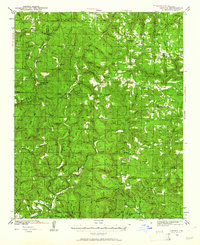 1940 Smyrna1961 Print · USGSThe Arkansas Ozarks around the Pope and Searcy county lines are shown here at a time when small mountain schools and isolated settlements were the heart of the community. Researchers can trace family roots at Old Smyrna Cem or find the sites of vanished homesteads near Lost Corner and Nogo Sch.2 unique versions available
 - 1943 Map of Smyrna
 1943 Smyrna1943 Print · USGSThe Boston Mountains of Pope and Van Buren counties appear in the early 1940s as a landscape of isolated ridges and headwater creeks. Genealogists and historians can trace the foundations of rural life at Old Smyrna Cem, Union Hill Sch, and the remote settlement of Nogo.
End of results
Showing maps 1-2 of 2
Top cities near Raspberry
Frequently asked questions
- What are the different types of historical maps available for Raspberry?
- What is the oldest map of Raspberry?
- Where can I purchase historical maps of Raspberry for my home or office?
- Where can I download high-res historical maps of Raspberry?
- Are there historical topographic maps available for Raspberry?
- Is there historical aerial imagery available for Raspberry?
- Where are historical maps of Raspberry sourced from?