1940s Maps of Ritz, Arkansas
Explore 3 historic maps of Ritz from the 1940s. These maps offer a rare glimpse into what life looked like during the 1940s — showing old roads, neighborhoods, homes, and landmarks that have changed or disappeared over time.
Whether you're researching your family's past, planning a metal detecting trip, or studying how Ritz's landscape evolved across the 1940s, these high-resolution maps are a powerful tool for exploring the history of this region.
- Focus on a specific era: All maps on this page are from the 1940s, giving you a focused view of this time period.
- See what’s changed: Compare century-old streets, trails, and buildings to today's modern landscape using overlays and satellite layers.
- Research with precision: Use these maps for genealogy, historical research, land use analysis, or educational projects.
- View, download, or print: Maps are fully viewable online in high resolution, and can be downloaded or printed for your own records.
Start exploring Ritz's history through authentic maps from the 1940s. This is your window into the past.
Ritz, AR maps
(3)- 1940 Map of Waldron
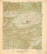 1940 Waldron1940 Print · USGSWaldron and the surrounding Ouachita highlands are shown here in the years leading up to the Second World War. Researchers can trace the heritage of rural Scott County through its many local schools and cemeteries, from Evening Shade Sch to the County Farm and Hon Cem.
 - 1941 Map of Waldron
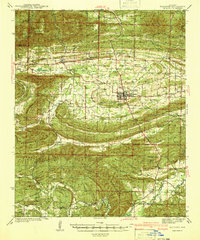 1941 Waldron1941 Print · USGSThe Scott County highlands come alive in the late 1930s, showing the vital rail junction at Waldron. Researchers can locate rural landmarks like Old Salem Ch, Hon Cem, and old mountain schoolhouses like Whisenhunt Sch.
 - 1949 Map of Waldron
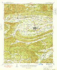 1949 Waldron1949 Print · USGSWaldron and the surrounding Scott County timberlands are captured here in the late 1940s as the railroad and river economy defined local life. Genealogists can trace family landmarks like Hon Cem, Square Rock Ch, and the old County Farm.2 unique versions available
End of results
Showing maps 1-3 of 3
Top cities near Ritz
Frequently asked questions
- What are the different types of historical maps available for Ritz?
- What is the oldest map of Ritz?
- Where can I purchase historical maps of Ritz for my home or office?
- Where can I download high-res historical maps of Ritz?
- Are there historical topographic maps available for Ritz?
- Is there historical aerial imagery available for Ritz?
- Where are historical maps of Ritz sourced from?