1940s Maps of Junction House, California
Explore 3 historic maps of Junction House from the 1940s. These maps offer a rare glimpse into what life looked like during the 1940s — showing old roads, neighborhoods, homes, and landmarks that have changed or disappeared over time.
Whether you're researching your family's past, planning a metal detecting trip, or studying how Junction House's landscape evolved across the 1940s, these high-resolution maps are a powerful tool for exploring the history of this region.
- Focus on a specific era: All maps on this page are from the 1940s, giving you a focused view of this time period.
- See what’s changed: Compare century-old streets, trails, and buildings to today's modern landscape using overlays and satellite layers.
- Research with precision: Use these maps for genealogy, historical research, land use analysis, or educational projects.
- View, download, or print: Maps are fully viewable online in high resolution, and can be downloaded or printed for your own records.
Start exploring Junction House's history through authentic maps from the 1940s. This is your window into the past.
Junction House, CA maps
(3)- 1947 Map of Brush Creek, 1963 Print
 1947 Brush Creek1963 Print · USGSButte County ranching and river life are captured here in the late 1940s as small settlements and family ranches dot the high timber country. Researchers can trace historic river bars like Evans Bar, the location of the Horseshoe Mine, and local landmarks like Sky High and Mountain House.
 - 1948 Map of Big Bend Mtn, 1953 Print
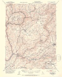 1948 Big Bend Mtn1953 Print · USGSIn the Sierra Nevada foothills during the late 1940s, this area remained a landscape of deep river canyons and historic mining camps. Genealogists and researchers can trace the old settlements of Forbestown and Enterprise, find the Indian Cemetery, or locate the Gold Bank Mine.4 unique versions available
 - 1949 Map of Brush Creek
 1949 Brush Creek1949 Print · USGSThe Butte County foothills appear in the late 1940s as a landscape of remote ranches and rugged river canyons. Researchers can trace family sites like Hinton Ranch or find the remote Sky High settlement and the Horseshoe Mine.2 unique versions available
End of results
Showing maps 1-3 of 3
Top cities near Junction House
Frequently asked questions
- What are the different types of historical maps available for Junction House?
- What is the oldest map of Junction House?
- Where can I purchase historical maps of Junction House for my home or office?
- Where can I download high-res historical maps of Junction House?
- Are there historical topographic maps available for Junction House?
- Is there historical aerial imagery available for Junction House?
- Where are historical maps of Junction House sourced from?