Old Maps of Spring Creek Recreation Residence Tract, El Dorado County for Hiking & Exploration
Hike through history with 12 historic maps of Spring Creek Recreation Residence Tract. Explore old trails, ghost towns, and forgotten backroads — perfect for outdoor adventurers and local explorers.
- Rediscover forgotten places: Map out old mining camps, roads, and footpaths that no longer exist on modern maps.
- Layer with modern tools: Combine with LiDAR or satellite views to plan hikes through historical terrain.
- Made for exploration: Popular among hikers, overlanders, and local history lovers.
Use these maps to find adventure and explore the hidden past of Spring Creek Recreation Residence Tract.
Spring Creek Recreation Residence Tract, El Dorado County maps
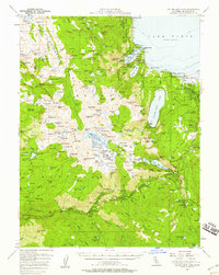
(12)- 1889 Map of Pyramid Peak, 1954 Print
 1889 Pyramid Peak1954 Print · USGSCovers Spring Creek Recreation Residence Tract, including South Lake Tahoe, Meyers, and other nearby areas
 - 1891 Map of Pyramid Peak
 1891 Pyramid Peak1891 Print · USGSCovers Spring Creek Recreation Residence Tract, including South Lake Tahoe, Meyers, and other nearby areas
 - 1895 Map of Pyramid Peak
 1895 Pyramid Peak1895 Print · USGSCovers Spring Creek Recreation Residence Tract, including South Lake Tahoe, Meyers, and other nearby areas2 unique versions available
 - 1896 Map of Pyramid Peak, 1905 Print
 1896 Pyramid Peak1905 Print · USGSCovers Spring Creek Recreation Residence Tract, including South Lake Tahoe, Meyers, and other nearby areas7 unique versions available
 - 1947 Map of Sacramento, 1948 Print
 1947 Sacramento1948 Print · USGSCovers Spring Creek Recreation Residence Tract, including Sacramento, Stockton, and other nearby areas2 unique versions available
 - 1948 Map of Sacramento, 1951 Print
 1948 Sacramento1951 Print · USGSCovers Spring Creek Recreation Residence Tract, including Sacramento, Stockton, and other nearby areas
 - 1955 Map of Emerald Bay, 1957 Print
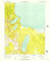 1955 Emerald Bay1957 Print · USGSCovers Spring Creek Recreation Residence Tract, including South Lake Tahoe, Tahoe Valley, and other nearby areas5 unique versions available
 - 1955 Map of Fallen Leaf Lake, 1958 Print
 1955 Fallen Leaf Lake1958 Print · USGSCovers Spring Creek Recreation Residence Tract, including South Lake Tahoe, Meyers, and other nearby areas7 unique versions available
 - 1956 Map of Sacramento
 1956 Sacramento1956 Print · USGSCovers Spring Creek Recreation Residence Tract, including Sacramento, Stockton, and other nearby areas2 unique versions available
 - 1957 Map of Sacramento, 1966 Print
 1957 Sacramento1966 Print · USGSCovers Spring Creek Recreation Residence Tract, including Sacramento, Stockton, and other nearby areas4 unique versions available
 - 1976 Map of Placerville, 1994 Print
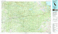 1976 Placerville1994 Print · USGSCovers Spring Creek Recreation Residence Tract, including South Lake Tahoe, Cameron Park, and other nearby areas2 unique versions available
 - 1992 Map of Emerald Bay, 1994 Print
 1992 Emerald Bay1994 Print · USGSCovers Spring Creek Recreation Residence Tract, including South Lake Tahoe, Tahoe Valley, and other nearby areas
End of results
Showing maps 1-12 of 12
Frequently asked questions
- What are the different types of historical maps available for Spring Creek Recreation Residence Tract?
- What is the oldest map of Spring Creek Recreation Residence Tract?
- Where can I purchase historical maps of Spring Creek Recreation Residence Tract for my home or office?
- Where can I download high-res historical maps of Spring Creek Recreation Residence Tract?
- Are there historical topographic maps available for Spring Creek Recreation Residence Tract?
- Is there historical aerial imagery available for Spring Creek Recreation Residence Tract?
- Where are historical maps of Spring Creek Recreation Residence Tract sourced from?