1940s Maps of Selma, California
Explore 5 historic maps of Selma from the 1940s. These maps offer a rare glimpse into what life looked like during the 1940s — showing old roads, neighborhoods, homes, and landmarks that have changed or disappeared over time.
Whether you're researching your family's past, planning a metal detecting trip, or studying how Selma's landscape evolved across the 1940s, these high-resolution maps are a powerful tool for exploring the history of this region.
- Focus on a specific era: All maps on this page are from the 1940s, giving you a focused view of this time period.
- See what’s changed: Compare century-old streets, trails, and buildings to today's modern landscape using overlays and satellite layers.
- Research with precision: Use these maps for genealogy, historical research, land use analysis, or educational projects.
- View, download, or print: Maps are fully viewable online in high resolution, and can be downloaded or printed for your own records.
Start exploring Selma's history through authentic maps from the 1940s. This is your window into the past.
Selma, CA maps
(5)- 1946 Map of Selma, 1954 Print
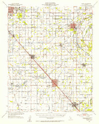 1946 Selma1954 Print · USGSFresno County's agricultural heartland is captured here in the mid-1940s, showing the extensive irrigation network supporting the valley's towns. Genealogists can locate family landmarks like Kings River Cemetery, Fruitvale School, and the Swedish Mission.2 unique versions available
 - 1946 Map of Selma, 1958 Print
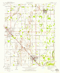 1946 Selma1958 Print · USGSThe fruit-growing heart of the San Joaquin Valley is mapped here just after the war as irrigation and rail lines fueled the growth of the Selma area. Genealogists and local historians can locate rural landmarks like Swedish Mission, Wineland, and the Oddfellows Cem.2 unique versions available
 - 1947 Map of Conejo
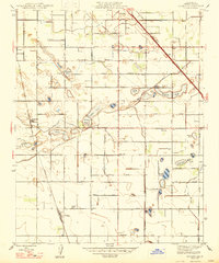 1947 Conejo1947 Print · USGSThe rural landscape of Fresno County comes into focus in the late 1940s, showing the intricate water and rail networks of the Central Valley. Genealogists can locate family-named features like Dudley Pond or Martin Pond and trace local education at the Conejo Sch.
 - 1947 Map of Selma
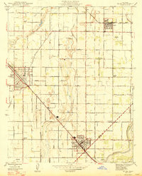 1947 Selma1947 Print · USGSThe fertile plains of Fresno County thrive in the late 1940s, anchored by the rail-centered towns of Selma and Kingsburg. Genealogists can trace family landmarks like Odd Fellows Cem or local schoolhouses such as Fruitvale Sch and Harrison Sch.2 unique versions available
 - 1948 Map of Fresno
 1948 Fresno1948 Print · USGSThe San Joaquin Valley and the High Sierra met during a period of rapid post-war growth and industrial expansion. Genealogists and researchers can trace family lines through small rail towns like Calwa City, find early aviation sites at Fresno-Chandler, or locate the Fresno Copper Mine.
End of results
Showing maps 1-5 of 5
Top cities near Selma
- Fresno historical maps
- Visalia historical maps
- Clovis historical maps
- Hanford historical maps
- Reedley historical maps
- Sanger historical maps
See more
Frequently asked questions
- What are the different types of historical maps available for Selma?
- What is the oldest map of Selma?
- Where can I purchase historical maps of Selma for my home or office?
- Where can I download high-res historical maps of Selma?
- Are there historical topographic maps available for Selma?
- Is there historical aerial imagery available for Selma?
- Where are historical maps of Selma sourced from?