1980s Maps of McKinleyville, California
Explore 2 historic maps of McKinleyville from the 1980s. These maps offer a rare glimpse into what life looked like during the 1980s — showing old roads, neighborhoods, homes, and landmarks that have changed or disappeared over time.
Whether you're researching your family's past, planning a metal detecting trip, or studying how McKinleyville's landscape evolved across the 1980s, these high-resolution maps are a powerful tool for exploring the history of this region.
- Focus on a specific era: All maps on this page are from the 1980s, giving you a focused view of this time period.
- See what’s changed: Compare century-old streets, trails, and buildings to today's modern landscape using overlays and satellite layers.
- Research with precision: Use these maps for genealogy, historical research, land use analysis, or educational projects.
- View, download, or print: Maps are fully viewable online in high resolution, and can be downloaded or printed for your own records.
Start exploring McKinleyville's history through authentic maps from the 1980s. This is your window into the past.
McKinleyville, CA maps
(2)- 1982 Map of Orick
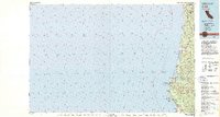 1982 Orick1982 Print · USGSCoastal Humboldt County in the early eighties reveals a landscape of massive redwood preserves and protected lagoons. Genealogists and historians can trace the foundations of Orick and Trinidad alongside the Trinidad Lighthouse and Trinidad Rancheria.
 - 1987 Map of Eureka
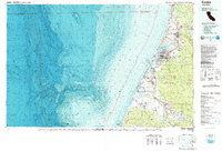 1987 Eureka1987 Print · USGSThe Humboldt County coastline in the late eighties reveals a landscape shaped by timber, transport, and the sea. Trace the Northwestern Pacific RR through Eureka or locate family roots near Ocean View Cem and Arlynda Corners.
End of results
Showing maps 1-2 of 2
Top cities near McKinleyville
Top neighborhoods of McKinleyville
Frequently asked questions
- What are the different types of historical maps available for McKinleyville?
- What is the oldest map of McKinleyville?
- Where can I purchase historical maps of McKinleyville for my home or office?
- Where can I download high-res historical maps of McKinleyville?
- Are there historical topographic maps available for McKinleyville?
- Is there historical aerial imagery available for McKinleyville?
- Where are historical maps of McKinleyville sourced from?