1990s Maps of Kearsarge, California
Explore 2 historic maps of Kearsarge from the 1990s. These maps offer a rare glimpse into what life looked like during the 1990s — showing old roads, neighborhoods, homes, and landmarks that have changed or disappeared over time.
Whether you're researching your family's past, planning a metal detecting trip, or studying how Kearsarge's landscape evolved across the 1990s, these high-resolution maps are a powerful tool for exploring the history of this region.
- Focus on a specific era: All maps on this page are from the 1990s, giving you a focused view of this time period.
- See what’s changed: Compare century-old streets, trails, and buildings to today's modern landscape using overlays and satellite layers.
- Research with precision: Use these maps for genealogy, historical research, land use analysis, or educational projects.
- View, download, or print: Maps are fully viewable online in high resolution, and can be downloaded or printed for your own records.
Start exploring Kearsarge's history through authentic maps from the 1990s. This is your window into the past.
Kearsarge, CA maps
(2)- 1992 Map of Bee Springs Canyon, 1995 Print
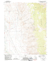 1992 Bee Springs Canyon1995 Print · USGSThe eastern slopes of the Inyo Mountains come to life in the early nineties, revealing a rugged landscape of mining and high-desert water sources. Researchers can trace the history of claims like the Black Eagle Mine and Old Whiteside Diggings near Bee Springs.
 - 1994 Map of Bee Springs Canyon, 1997 Print
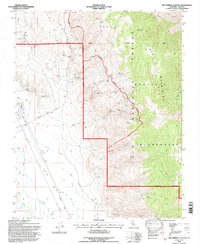 1994 Bee Springs Canyon1997 Print · USGSInyo County's rugged mining and irrigation history is on full display in this mid-1990s record of the high desert. Researchers can trace historic extraction sites like the Black Eagle Mine and follow the route of the Old Railroad Grade and Mc Iver Canal across the valley floor.2 unique versions available
End of results
Showing maps 1-2 of 2
Top cities near Kearsarge
Frequently asked questions
- What are the different types of historical maps available for Kearsarge?
- What is the oldest map of Kearsarge?
- Where can I purchase historical maps of Kearsarge for my home or office?
- Where can I download high-res historical maps of Kearsarge?
- Are there historical topographic maps available for Kearsarge?
- Is there historical aerial imagery available for Kearsarge?
- Where are historical maps of Kearsarge sourced from?