1940s Maps of Grapevine, California
Explore 3 historic maps of Grapevine from the 1940s. These maps offer a rare glimpse into what life looked like during the 1940s — showing old roads, neighborhoods, homes, and landmarks that have changed or disappeared over time.
Whether you're researching your family's past, planning a metal detecting trip, or studying how Grapevine's landscape evolved across the 1940s, these high-resolution maps are a powerful tool for exploring the history of this region.
- Focus on a specific era: All maps on this page are from the 1940s, giving you a focused view of this time period.
- See what’s changed: Compare century-old streets, trails, and buildings to today's modern landscape using overlays and satellite layers.
- Research with precision: Use these maps for genealogy, historical research, land use analysis, or educational projects.
- View, download, or print: Maps are fully viewable online in high resolution, and can be downloaded or printed for your own records.
Start exploring Grapevine's history through authentic maps from the 1940s. This is your window into the past.
Grapevine, CA maps
(3)- 1942 Map of Tecuya Creek, 1957 Print
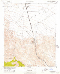 1942 Tecuya Creek1957 Print · USGSThe critical mountain pass of the Grapevine is captured here during the early 1940s as a vital energy and transport corridor. Trace the early industrial footprint of the General Petroleum Corp Rose Station and the high-altitude Kern Co Police Radio Relay Station.
 - 1945 Map of Tecuya Creek
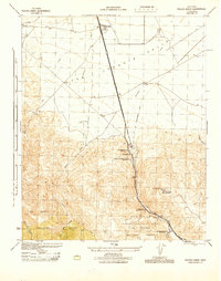 1945 Tecuya Creek1945 Print · USGSThe critical mountain passage into the southern San Joaquin Valley is documented here during the mid-1940s. Trace the early industrial footprint of the petroleum industry at Richfield Oil Co Pumping Sta and Grapevine along the historic route of Highway 99.
 - 1949 Map of Los Angeles
 1949 Los Angeles1949 Print · USGSSouthern California and the South Coast appear at the onset of the post-war boom, from the Channel Islands to the Mojave Desert. Trace early aviation sites like Lockheed Air Terminal and mining history at the Redrock Quicksilver Mine and Redrover Mine.2 unique versions available
End of results
Showing maps 1-3 of 3
Frequently asked questions
- What are the different types of historical maps available for Grapevine?
- What is the oldest map of Grapevine?
- Where can I purchase historical maps of Grapevine for my home or office?
- Where can I download high-res historical maps of Grapevine?
- Are there historical topographic maps available for Grapevine?
- Is there historical aerial imagery available for Grapevine?
- Where are historical maps of Grapevine sourced from?