1930s Maps of Antelope Center, California
Explore 2 historic maps of Antelope Center from the 1930s. These maps offer a rare glimpse into what life looked like during the 1930s — showing old roads, neighborhoods, homes, and landmarks that have changed or disappeared over time.
Whether you're researching your family's past, planning a metal detecting trip, or studying how Antelope Center's landscape evolved across the 1930s, these high-resolution maps are a powerful tool for exploring the history of this region.
- Focus on a specific era: All maps on this page are from the 1930s, giving you a focused view of this time period.
- See what’s changed: Compare century-old streets, trails, and buildings to today's modern landscape using overlays and satellite layers.
- Research with precision: Use these maps for genealogy, historical research, land use analysis, or educational projects.
- View, download, or print: Maps are fully viewable online in high resolution, and can be downloaded or printed for your own records.
Start exploring Antelope Center's history through authentic maps from the 1930s. This is your window into the past.
Antelope Center, CA maps
(2)- 1930 Map of Little Rock
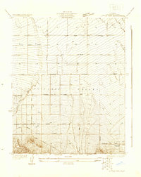 1930 Little Rock1930 Print · USGSAntelope Valley in the early thirties reveals a developing high-desert agricultural landscape defined by citrus-named routes and irrigation. Researchers can trace the layout of the Almondale settlement or locate early desert infrastructure like the Little Rock Ditch and the Apple Blossom Highway.
 - 1934 Map of Little Rock
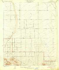 1934 Little Rock1934 Print · USGSAntelope Valley in the early thirties reveals a burgeoning agricultural landscape structured by a precise road grid and early highway routes. Genealogists and historians can trace the foundations of Little Rock, the outskirts of Almondale, and the irrigation network of Little Rock Ditch.4 unique versions available
End of results
Showing maps 1-2 of 2
Top cities near Antelope Center
Frequently asked questions
- What are the different types of historical maps available for Antelope Center?
- What is the oldest map of Antelope Center?
- Where can I purchase historical maps of Antelope Center for my home or office?
- Where can I download high-res historical maps of Antelope Center?
- Are there historical topographic maps available for Antelope Center?
- Is there historical aerial imagery available for Antelope Center?
- Where are historical maps of Antelope Center sourced from?