1930s Maps of Boiling Point, California
Explore 2 historic maps of Boiling Point from the 1930s. These maps offer a rare glimpse into what life looked like during the 1930s — showing old roads, neighborhoods, homes, and landmarks that have changed or disappeared over time.
Whether you're researching your family's past, planning a metal detecting trip, or studying how Boiling Point's landscape evolved across the 1930s, these high-resolution maps are a powerful tool for exploring the history of this region.
- Focus on a specific era: All maps on this page are from the 1930s, giving you a focused view of this time period.
- See what’s changed: Compare century-old streets, trails, and buildings to today's modern landscape using overlays and satellite layers.
- Research with precision: Use these maps for genealogy, historical research, land use analysis, or educational projects.
- View, download, or print: Maps are fully viewable online in high resolution, and can be downloaded or printed for your own records.
Start exploring Boiling Point's history through authentic maps from the 1930s. This is your window into the past.
Boiling Point, CA maps
(2)- 1932 Map of Red Rover
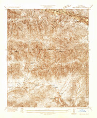 1932 Red Rover1932 Print · USGSNorthern Los Angeles County in the early thirties reveals a landscape of remote mountain ranches and early roadside service. Trace the San Andreas Rift Zone or locate family landmarks like Ritter Ranch and the Red Rover Mine.
 - 1937 Map of Red Rover
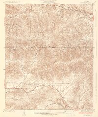 1937 Red Rover1937 Print · USGSLos Angeles County's northern high desert and the Sierra Pelona mountains come into focus during the mid-1930s. Researchers can locate remote ranching outposts like Hauser Ranch and active mining sites including the Puritan Mine and Red Rover Mine.5 unique versions available
End of results
Showing maps 1-2 of 2
Top cities near Boiling Point
- Los Angeles historical maps
- Santa Clarita historical maps
- Palmdale historical maps
- Lancaster historical maps
- San Fernando historical maps
Frequently asked questions
- What are the different types of historical maps available for Boiling Point?
- What is the oldest map of Boiling Point?
- Where can I purchase historical maps of Boiling Point for my home or office?
- Where can I download high-res historical maps of Boiling Point?
- Are there historical topographic maps available for Boiling Point?
- Is there historical aerial imagery available for Boiling Point?
- Where are historical maps of Boiling Point sourced from?